

| Mesoscale Discussion 1812 | |
| < Previous MD | |

|
|
   Mesoscale Discussion 1812
   NWS Storm Prediction Center Norman OK
   0330 PM CDT Fri Jul 31 2026

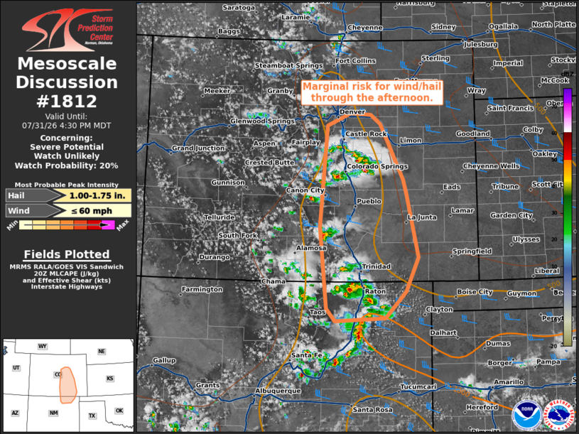
   Areas affected...central/eastern Colorado...northeastern New Mexico

   Concerning...Severe potential...Watch unlikely

   Valid 312030Z - 312230Z

   Probability of Watch Issuance...20 percent

   SUMMARY...Marginal risk for damaging wind and hail this afternoon.

   DISCUSSION...Thunderstorms have developed across the high terrain in
   central and eastern Colorado into northeastern New Mexico.
   Instability is modest, but steep low to mid-level lapse rates and
   sufficient deep layer shear should support some potential for a few
   organized storms. Deeply mixed profiles, inverted-v profiles, and
   steep low to mid-level lapse rates will support outflow dominate
   storms with potential for damaging wind. A few instances of severe
   hail will also be possible. Generally, this threat is expected to be
   isolated and a watch is unlikely to be needed.

   ..Thornton/Mosier.. 07/31/2026

   ...Please see www.spc.noaa.gov for graphic product...

   ATTN...WFO...PUB...BOU...ABQ...

   LAT...LON   36380397 36330503 36550520 37900534 39590520 39790471
               39760428 39620408 39290391 39060378 38680359 38440352
               37400329 36820355 36380397

   MOST PROBABLE PEAK WIND GUST...UP TO 60 MPH
   MOST PROBABLE PEAK HAIL SIZE...1.00-1.75 IN
|
|
|
Top/All Mesoscale Discussions/Forecast Products/Home |
|
Source link