

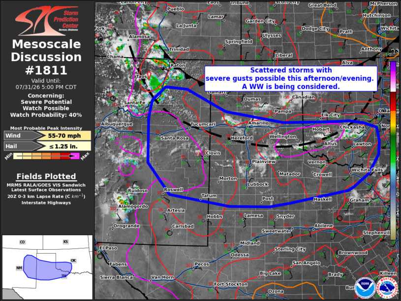
| Mesoscale Discussion 1811 | |
| < Previous MD | |

|
|
   Mesoscale Discussion 1811
   NWS Storm Prediction Center Norman OK
   0303 PM CDT Fri Jul 31 2026

   Areas affected...parts of eastern New Mexico the Texas Panhandle and
   southwest Oklahoma

   Concerning...Severe potential...Watch possible

   Valid 312003Z - 312200Z

   Probability of Watch Issuance...40 percent

   SUMMARY...A very hot air mass will support scattered thunderstorms
   across parts of the southern Plains this afternoon and evening.
   Strong to severe gusts are possible. A WW is being considered.

   DISCUSSION...As of 20 UTC, visible imagery and surface observations
   showed increasing cumulus and thunderstorms along a surface wind
   shift/cold front and over northeastern NM. Strong heating is
   contributing to moderate destabilization (SBCAPE of 1000-2000 J/kg)
   from southwest OK, into the TX Panhandle and eastern NM on the
   southwestern periphery of an upper trough progressing through the
   Midwest. As weak ascent overspreads the warming air mass
   thunderstorms should increase in coverage/intensity this afternoon,
   moving off the higher terrain in NM and ahead of the cold front
   farther east.

   The surface air mass is very hot (100-105 F) and deeply mixed which
   is supporting very steep low-level lapse rates of 8-9 C/km. Deep
   inverted-v structures will encourage effect downdrafts with strong
   to severe gusts possible with the most robust storms. Moderate
   effective shear of 20-25 kt will support a multicell storm mode with
   some clustering given the expected strength of the outflow.

   The severe risk appears likely to focus east of the higher terrain
   in NM with scattered severe storms. With time, some clustering would
   spread east/southeastward into the western TX Panhandle with a
   continued risk for strong to severe gusts as depicted by 12z CAMS.
   More isolated storms may also develop and intensify along the wind
   shift and weak cold front across the TX Panhandle and southwest OK.
   Given the expected increase in storm coverage, a Severe Thunderstorm
   Watch is possible this afternoon.

   ..Lyons/Mosier.. 07/31/2026

   ...Please see www.spc.noaa.gov for graphic product...

   ATTN...WFO...FWD...OUN...SJT...LUB...AMA...MAF...ABQ...

   LAT...LON   33050110 33070239 33350430 34200503 35390506 35880497
               36250453 36190382 35630259 35610249 35320063 35319933
               35319881 35339848 35259800 35139759 34779751 34399756
               33889790 33549839 33459858 33140046 33050110

   MOST PROBABLE PEAK WIND GUST...55-70 MPH
   MOST PROBABLE PEAK HAIL SIZE...UP TO 1.25 IN
|
|
|
Top/All Mesoscale Discussions/Forecast Products/Home |
|
Source link