

| Mesoscale Discussion 1810 | |
| < Previous MD | |

|
|
   Mesoscale Discussion 1810
   NWS Storm Prediction Center Norman OK
   0213 PM CDT Fri Jul 31 2026

   Areas affected...much of central/eastern Missouri into western
   Illinois

   Concerning...Severe potential...Watch likely

   Valid 311913Z - 312115Z

   Probability of Watch Issuance...80 percent

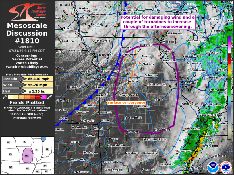
   SUMMARY...Potential for damaging wind and a couple of tornadoes to
   increase through the afternoon/evening.

   DISCUSSION...Air mass recovery is ongoing across portions of western
   and central Missouri behind morning thunderstorm activity. A surface
   low is currently located across central Iowa, with modest south to
   southwesterly flow and temperatures warming back into the mid 80s
   across Missouri. SPC Mesoanalysis depicts higher theta-e air
   advecting in from the southwest and a nose of MLCAPE values around
   1000-2000 J/kg are slowly shifting northward into portions of
   north-central Missouri. Additionally, visible satellite shows
   cumulus becoming increasingly agitated near the front.

   This destabilization ahead of the approaching front will be
   sufficient to support redevelopment of severe storms over the next
   couple of hours both near the front and along surface convergence
   with the surface trough in central Missouri. Deep layer shear around
   35-40 kts will support supercells. The main threats will likely be
   damaging wind and a couple or tornadoes. Tornado potential will be
   best where surface winds have a southeasterly component maximizing
   low-level SRH. This zone appears most likely across portions of
   central/eastern Missouri near the surface trough. A watch will
   likely be needed to cover these potential threats in the next couple
   of hours.

   ..Thornton/Mosier.. 07/31/2026

   ...Please see www.spc.noaa.gov for graphic product...

   ATTN...WFO...PAH...LSX...DVN...SGF...EAX...

   LAT...LON   37369368 38189389 38469383 38919372 39659353 39769343
               40009317 40119292 40219262 40259218 40299184 40309160
               40299139 40299137 40189110 39969082 39599067 39079054
               38719052 38229054 37709065 37179076 36979082 36669163
               36699222 36709261 36739329 36879353 37229364 37369368

   MOST PROBABLE PEAK TORNADO INTENSITY...85-110 MPH
   MOST PROBABLE PEAK WIND GUST...55-70 MPH
   MOST PROBABLE PEAK HAIL SIZE...UP TO 1.25 IN
|
|
|
Top/All Mesoscale Discussions/Forecast Products/Home |
|
Source link