

| Mesoscale Discussion 1808 | |
| < Previous MD | |

|
|
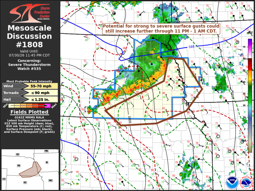
Mesoscale Discussion 1808 NWS Storm Prediction Center Norman OK 0944 PM CDT Thu Jul 30 2026 Areas affected...southern/eastern Nebraska...adjacent southwestern Iowa Concerning...Severe Thunderstorm Watch 535... Valid 310244Z - 310445Z The severe weather threat for Severe Thunderstorm Watch 535 continues. SUMMARY...A cluster of strong thunderstorms is likely to be maintained at least several more hours while propagating southeastward toward the lower Missouri Valley. Potential for strong to severe surface gusts may still increase further. Trends will continue to be monitored for the possibility of an additional downstream watch. DISCUSSION...Updraft inflow of seasonably high boundary-layer moisture content supportive of large CAPE has contributed to the maintenance of vigorous thunderstorm development, which continues to consolidate a bit along the leading edge of the southeastward advancing surface cold pool. 2-hourly surface pressure rises on the order of 2-3 mb have been evident in a narrow corridor now approaching the Kearney, Hastings and perhaps Columbus vicinities. An MCV remains fairly well-defined as it migrates across and east-southeast of the Norfolk vicinity, with 50-60 kt northwesterly rear-inflow evident to its southwest. Due to relatively moist profiles with somewhat modest lower/mid-tropospheric lapse rates, downward mixing of this momentum to the surface has been slowed. However, strong to severe gusts reaching the surface could still continue to increase as peak convective intensities are maintained at least a few more hours while propagating southeastward toward the lower Missouri Valley. ..Kerr.. 07/31/2026 ...Please see www.spc.noaa.gov for graphic product... ATTN...WFO...DMX...EAX...OAX...TOP...GID... LAT...LON 41379684 42199662 42159589 41059500 40289578 39829718 39749886 40269961 41379684 MOST PROBABLE PEAK TORNADO INTENSITY...UP TO 90 MPH MOST PROBABLE PEAK WIND GUST...55-70 MPH MOST PROBABLE PEAK HAIL SIZE...UP TO 1.25 IN |
|
|
Top/All Mesoscale Discussions/Forecast Products/Home |
|
Source link