

| Mesoscale Discussion 1807 | |
| < Previous MD | |

|
|
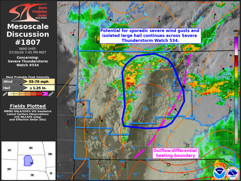
Mesoscale Discussion 1807 NWS Storm Prediction Center Norman OK 0647 PM CDT Thu Jul 30 2026 Areas affected...portions of central and north-central South Dakota Concerning...Severe Thunderstorm Watch 534... Valid 302347Z - 310145Z The severe weather threat for Severe Thunderstorm Watch 534 continues. SUMMARY...The potential for sporadic severe wind gusts and isolated large hail continues across portions of Severe Thunderstorm Watch 534. DISCUSSION...Ongoing convection across western South Dakota has formed into a loosely organized cluster over the past 1-2 hours, with sporadic reports of severe wind gusts and an isolated report of 1" hail noted with this activity. A narrow corridor of greater MLCAPE collocated with warmer surface temperatures and a local minimum in cloud cover exists downstream of this activity, with a convective outflow/differential heating boundary located farther to the east. This corridor of greater buoyancy will continue to support a risk for sporadic severe wind gusts and an instance or two of large hail over the next couple of hours as ongoing convection progresses east/southeastward. The overall severe risk should then gradually subside into the overnight hours as convection encounters a less unstable air mass. ..Chalmers.. 07/30/2026 ...Please see www.spc.noaa.gov for graphic product... ATTN...WFO...ABR...UNR... LAT...LON 45370025 45200015 44869996 44589993 44260017 44010043 43900064 43870093 43860143 43870151 43920223 44080229 44460220 45000225 45240229 45390231 45580219 45720198 45820175 45880105 45740055 45560037 45370025 MOST PROBABLE PEAK WIND GUST...55-70 MPH MOST PROBABLE PEAK HAIL SIZE...UP TO 1.25 IN |
|
|
Top/All Mesoscale Discussions/Forecast Products/Home |
|
Source link