

| Mesoscale Discussion 1806 | |
| < Previous MD | |

|
|
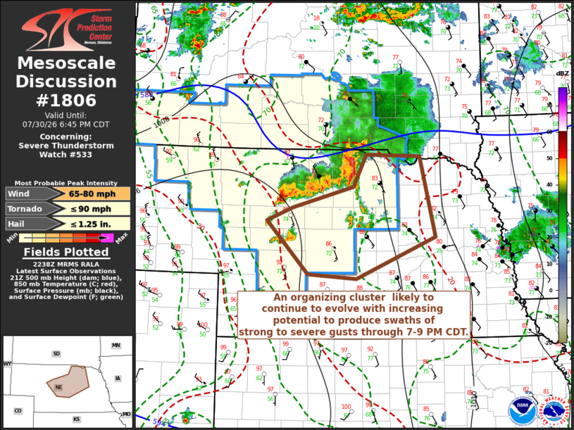
Mesoscale Discussion 1806 NWS Storm Prediction Center Norman OK 0541 PM CDT Thu Jul 30 2026 Areas affected...much of central Nebraska Concerning...Severe Thunderstorm Watch 533... Valid 302241Z - 302345Z The severe weather threat for Severe Thunderstorm Watch 533 continues. SUMMARY...A growing and organizing cluster of storms accompanied by increasing potential to produce swaths of strong to severe wind gusts appears probable through 7-9 PM CDT. Trends are being monitored for the possibility of an additional severe weather watch east and south of Severe Thunderstorm Watch 533. DISCUSSION...Vigorous convective development continues to gradually grow upscale, with an expanding and strengthening surface cold pool, which will continue to slowly advance south of the Winner SD, Valentine and Ainsworth NE vicinities during the next few hours. The most intense cell has generally been focused along the southwestern flank of the outflow, where low-level convergence has become enhanced near its intersection with a weak wind shift within broader weak surface troughing. However, south-southeasterly updraft inflow of seasonably high low-level moisture content (which appears to be contributing to CAPE in excess of 3000 J/kg) may support a broader area of intensifying convection into the 00-02Z time frame. Although deep-layer westerly mean flow is still modest (on the order of 20 kt), due to pronounced veering of low through mid-level wind fields, shear through the lowest 5-6 km is strong and may support the evolution of an organizing cluster with increasing potential to produce swaths of strong to severe wind gusts. ..Kerr.. 07/30/2026 ...Please see www.spc.noaa.gov for graphic product... ATTN...WFO...FSD...OAX...GID...LBF... LAT...LON 42080050 42419922 42929895 42889782 41609750 40949917 41010019 41870106 42080050 MOST PROBABLE PEAK TORNADO INTENSITY...UP TO 90 MPH MOST PROBABLE PEAK WIND GUST...65-80 MPH MOST PROBABLE PEAK HAIL SIZE...UP TO 1.25 IN |
|
|
Top/All Mesoscale Discussions/Forecast Products/Home |
|
Source link