

| Mesoscale Discussion 1801 | |
| < Previous MD | |

|
|
   Mesoscale Discussion 1801
   NWS Storm Prediction Center Norman OK
   1231 PM CDT Thu Jul 30 2026

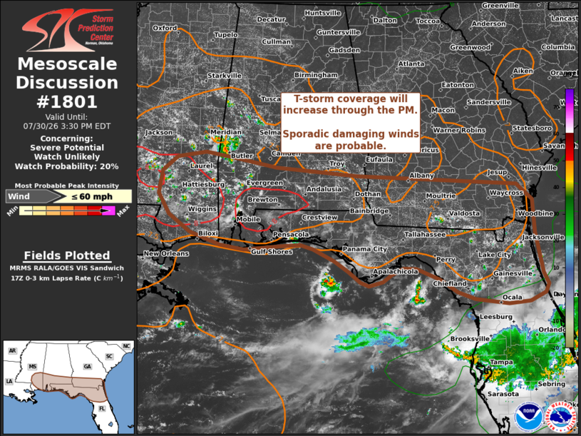
   Areas affected...Southern portions of Mississippi...Alabama...and
   Georgia into northern Florida

   Concerning...Severe potential...Watch unlikely

   Valid 301731Z - 301930Z

   Probability of Watch Issuance...20 percent

   SUMMARY...Isolated to widely scattered thunderstorms will develop
   through the afternoon hours. Isolated instances of damaging winds
   are probable given a favorable thermodynamic environment. However,
   poor deep-layer wind shear will likely limit the overall coverage
   and duration of severe thunderstorms and negate the need for a
   watch.

   DISCUSSION...Latest GOES imagery and MRMS mosaics depict the early
   stages of deep convection across southern MS/AL with growing cumulus
   also noted into southern GA and northern FL. This activity should
   continue to grow in coverage and intensity in the coming hours as
   surface temperatures continue to warm into the mid/upper 90s with a
   very moist environment. Based on latest RAP mesoanalysis estimates,
   MLCAPE values are increasing to 2000 J/kg, and should easily climb
   to the 2500-3000 J/kg range by mid afternoon. Additionally,
   low-level lapse rates will continue to steepen to near dry-adiabatic
   within the lowest 1-2 km in the coming hours. Despite a favorable
   thermodynamic environment for robust convection, regional VWPs and
   high-res forecast soundings suggest deep-layer wind shear is very
   weak across the region (20 knots or less).

   Given these environmental parameters, the expectation is for
   short-lived, outflow-dominant convection to expand in coverage
   through the afternoon with an attendant threat for strong downbursts
   capable of producing swaths of damaging winds (most likely peaking
   in the 40-60 mph range). Some clustering appears possible and could
   yield corridors of higher wind damage potential, but predictability
   of when and where such clustering will occur appears limited at this
   time. In general, the severe threat should be sufficiently transient
   and isolated to preclude watch issuance.

   ..Moore/Mosier.. 07/30/2026

   ...Please see www.spc.noaa.gov for graphic product...

   ATTN...WFO...MLB...TBW...JAX...TAE...BMX...MOB...JAN...LIX...

   LAT...LON   30288701 30218783 30288837 30528904 30858953 31248977
               31698971 31978937 32078872 31978802 31808712 31668528
               31468171 31168136 30518133 30138124 29748116 29528105
               29358113 29208147 29168195 29258269 29398308 29648347
               29858398 29878426 29748452 29608472 29528503 29608523
               29818549 30008581 30248628 30318657 30288701

   MOST PROBABLE PEAK WIND GUST...UP TO 60 MPH
|
|
|
Top/All Mesoscale Discussions/Forecast Products/Home |
|
Source link