

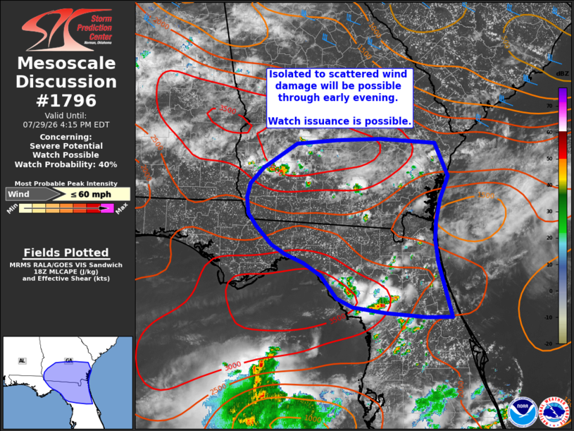
| Mesoscale Discussion 1796 | |
| < Previous MD | |

|
|
   Mesoscale Discussion 1796
   NWS Storm Prediction Center Norman OK
   0122 PM CDT Wed Jul 29 2026

   Areas affected...Southern Georgia into northern Florida

   Concerning...Severe potential...Watch possible

   Valid 291822Z - 292015Z

   Probability of Watch Issuance...40 percent

   SUMMARY...Thunderstorms developing across southern Georgia into
   northern Florida will likely pose a threat for isolated, to perhaps
   scattered, wind damage through the late afternoon and early evening
   hours. Watch issuance is possible if thunderstorm clustering occurs
   and poses a more widespread severe threat.

   DISCUSSION...Latest GOES imagery shows the early stages of
   thunderstorm development across southern GA and parts of northern
   FL. Convection developing across southern GA is primarily being
   driven by ascent along a weak/diffuse surface cold front where
   strong heating is occurring (temperatures continue to warm into the
   upper 90s to low 100s) and is supporting MLCAPE values upwards of
   3000 J/kg. These hot temperature are also supporting steep low-level
   lapse rates on the order of 8 to 8.5 C/km, which will foster
   accelerating downdrafts with a damaging/severe wind risk with any
   deep/robust convective core.

   Continued thunderstorm development along the front is anticipated in
   the coming hours as further heating occurs, though weak forcing for
   ascent casts some uncertainty on the overall coverage of convection
   (most likely isolated to scattered). VWPs across southern
   GA/northern FL continue to sample very weak flow aloft (generally
   less than 20 knots), but stronger flow (25-35 knots) appears to be
   glancing central GA based on upstream VWP observations. This may
   support somewhat better organization/clustering of convection across
   southeast GA through the afternoon, which may yield one or more
   focused corridors of damaging wind potential. Convective trends will
   continue to be monitored, and watch issuance is possible if/when
   such clusters begin to emerge through the afternoon.

   ..Moore/Hart.. 07/29/2026

   ...Please see www.spc.noaa.gov for graphic product...

   ATTN...WFO...CHS...MLB...TBW...JAX...FFC...TAE...

   LAT...LON   31528460 31918398 31988324 32008243 31938142 31408118
               31038134 30688141 30398143 30028138 29168114 29158160
               29228236 29318296 29468324 29828353 30018385 30168419
               30318444 30598472 30808487 31058491 31288485 31528460

   MOST PROBABLE PEAK WIND GUST...UP TO 60 MPH
|
|
|
Top/All Mesoscale Discussions/Forecast Products/Home |
|
Source link