

| Mesoscale Discussion 1776 | |
| < Previous MD | |

|
|
   Mesoscale Discussion 1776
   NWS Storm Prediction Center Norman OK
   0802 PM CDT Mon Jul 27 2026

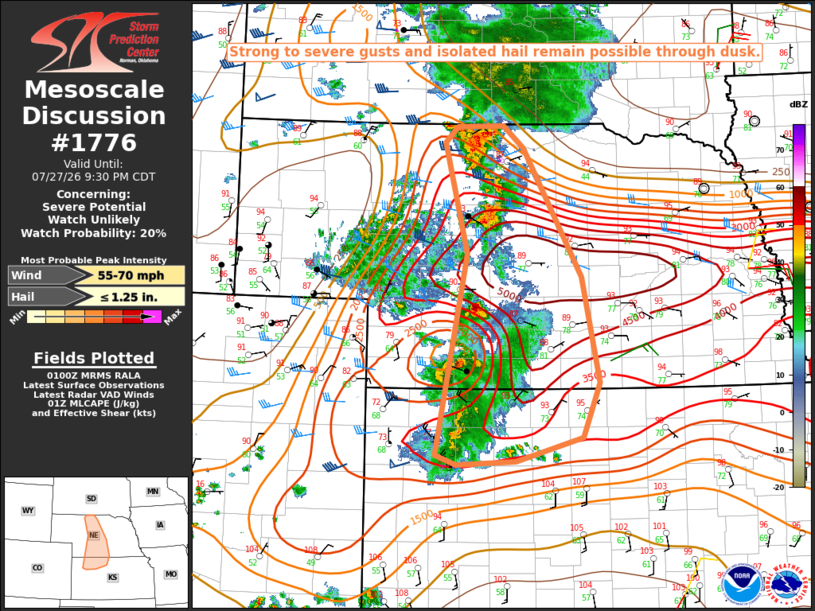
   Areas affected...Parts of western/central NE into northwest KS

   Concerning...Severe potential...Watch unlikely

   Valid 280102Z - 280230Z

   Probability of Watch Issuance...20 percent

   SUMMARY...Strong to severe gusts and isolated hail remain possible
   through dusk.

   DISCUSSION...Strong to locally severe storms are ongoing this
   evening from west-central NE into northwest KS, in advance of a
   low-amplitude midlevel shortwave trough moving across the central
   High Plains. Very rich low-level moisture is in place across the
   region, with the 0-1 km mean mixing ratio of 19.8 on the 00Z LBF
   sounding very near an all-time record for the site (per SPC's
   sounding climatology). This moisture is resulting in strong to
   extreme buoyancy (MLCAPE of 3000-5000 J/kg), despite rather warm
   temperatures aloft. Effective shear of 30-40 kt is sufficient for at
   least modest storm organization, with organized multicells and
   perhaps a supercell or two possible through dusk. Large PW and
   relatively favorable lapse rates will continue to support strong to
   locally severe gusts, and isolated hail cannot be ruled out with the
   strongest cells.

   ..Dean/Smith.. 07/28/2026

   ...Please see www.spc.noaa.gov for graphic product...

   ATTN...WFO...GID...LBF...GLD...

   LAT...LON   39240103 41520057 42780091 42970071 42980003 42729973
               41279885 40069859 39449885 39189983 39150031 39130072
               39240103

   MOST PROBABLE PEAK WIND GUST...55-70 MPH
   MOST PROBABLE PEAK HAIL SIZE...UP TO 1.25 IN
|
|
|
Top/All Mesoscale Discussions/Forecast Products/Home |
|
Source link