

| Mesoscale Discussion 1767 | |
| < Previous MD Next MD > | |

|
|
   Mesoscale Discussion 1767
   NWS Storm Prediction Center Norman OK
   0213 PM CDT Mon Jul 27 2026

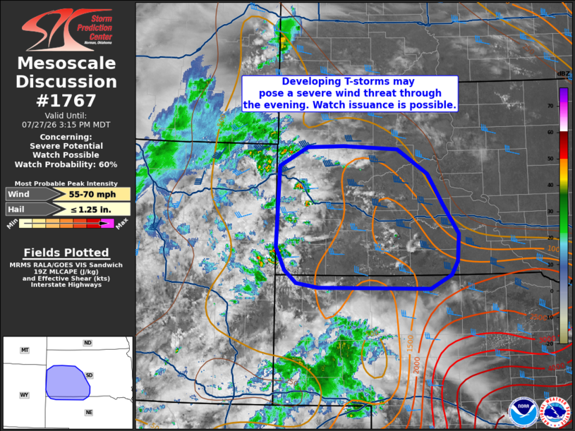
   Areas affected...Southwest South Dakota and adjacent portions of
   northwest Nebraska

   Concerning...Severe potential...Watch possible

   Valid 271913Z - 272115Z

   Probability of Watch Issuance...60 percent

   SUMMARY...Thunderstorms developing across southwest South Dakota
   will likely pose a severe wind threat as they spread east across
   South Dakota and northwest Nebraska. Watch issuance may be required
   to address this potential.

   DISCUSSION...Recent visible/reflectivity imagery and lightning data
   shows early stages of deep convection within the Black Hills in
   southwest SD. This activity is largely being driven by weak upslope
   ascent, but should gradually propagate eastward as convection
   deepens and becomes increasingly influenced by mean westerly flow
   aloft. However, the KUDX VWP has recently sampled somewhat modest
   winds between 5-7 km (around 25 knots), resulting in slightly weaker
   deep-layer bulk shear than depicted by recent mesoanalyses.
   Regardless, the thermodynamic environment features sufficient
   buoyancy for sustained deep convection - especially with eastward
   extent into a plume of low 60s dewpoints. Additionally, strong
   heating has steepened low-level lapse rates to around 9 C/km
   downstream, which should foster cold pool development and further
   promote eastward propagation.

   Consequently, the expectation is for initially discrete convection
   to gradually grow upscale and propagate eastward through the evening
   hours. Severe winds will be the primary concern and could be as
   strong as 55-70 mph based on environmental conditions and output
   from recent high-res guidance, though the modest kinematic
   environment casts some uncertainty on overall storm
   organization/intensity. Trends will continue to be monitored and
   watch issuance may be required if/when upscale growth occurs.

   ..Moore/Hart.. 07/27/2026

   ...Please see www.spc.noaa.gov for graphic product...

   ATTN...WFO...ABR...LBF...UNR...CYS...

   LAT...LON   42780079 42800315 42880361 43070386 43420405 44670399
               44960340 44980263 44920148 44540085 44070053 43620019
               43200023 43000036 42780079

   MOST PROBABLE PEAK WIND GUST...55-70 MPH
   MOST PROBABLE PEAK HAIL SIZE...UP TO 1.25 IN
|
|
|
Top/All Mesoscale Discussions/Forecast Products/Home |
|
Source link