

| Mesoscale Discussion 1747 | |
| < Previous MD | |

|
|
   Mesoscale Discussion 1747
   NWS Storm Prediction Center Norman OK
   0516 PM CDT Sun Jul 26 2026

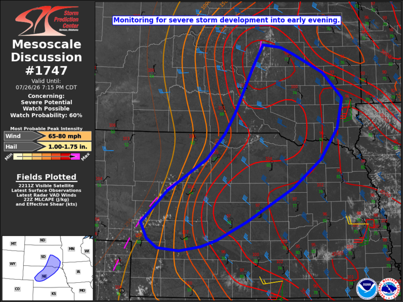
   Areas affected...Parts of western/central NE into southeast SD

   Concerning...Severe potential...Watch possible

   Valid 262216Z - 270015Z

   Probability of Watch Issuance...60 percent

   SUMMARY...Severe storms may develop into early evening. Watch
   issuance is possible.

   DISCUSSION...Cumulus is gradually increasing this afternoon from
   west-central NE into southeast SD, in the vicinity of a surface
   trough. Temperatures have warmed well above 100 F near the trough,
   with rich low-level moisture and steep lapse rates supporting MLCAPE
   of around 2000 J/kg from west-central NE to over 4000 J/kg into
   southeast SD, per recent objective mesoanalyses. Veering wind
   profiles with modest northwesterly mid/upper-level flow are
   resulting in effective shear of 30-40 kt, conditionally favorable
   for organized convection.

   With generally weak large-scale ascent across the region, timing and
   coverage of storm development remains somewhat uncertain. However,
   at least isolated severe-storm development is expected by early
   evening, given the very favorable thermodynamic environment and
   presence of a surface boundary. Severe gusts of 60-80 mph appear to
   be the most likely hazard within the steep low-level lapse rate
   environment, though if a supercell or two can evolve with time, then
   an isolated hail threat will also be possible. Watch issuance is
   possible by early evening in order to address these threats.

   ..Dean/Smith.. 07/26/2026

   ...Please see www.spc.noaa.gov for graphic product...

   ATTN...WFO...FSD...OAX...ABR...GID...LBF...UNR...

   LAT...LON   40840091 40890144 41060169 41350184 41920123 42510027
               42989983 43349958 44209912 44599889 44549843 44419813
               44079741 43619693 43079706 42519746 41999815 41389927
               41050001 40930040 40840091

   MOST PROBABLE PEAK WIND GUST...65-80 MPH
   MOST PROBABLE PEAK HAIL SIZE...1.00-1.75 IN
|
|
|
Top/All Mesoscale Discussions/Forecast Products/Home |
|
Source link