

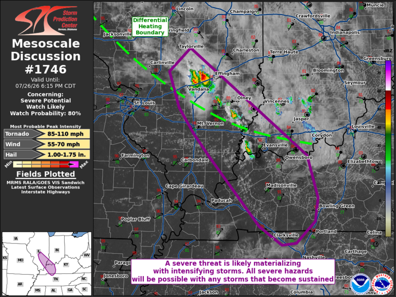
| Mesoscale Discussion 1746 | |
| < Previous MD | |

|
|
   Mesoscale Discussion 1746
   NWS Storm Prediction Center Norman OK
   0448 PM CDT Sun Jul 26 2026

   Areas affected...portions of southeastern Illinois into far
   southwestern Indiana...western Kentucky...far northern middle
   Tennessee

   Concerning...Severe potential...Watch likely

   Valid 262148Z - 262315Z

   Probability of Watch Issuance...80 percent

   SUMMARY...The severe threat is increasing, with supercells likely to
   mature in the next couple of hours. Severe wind/hail and at least a
   few tornadoes are possible. A WW issuance may be needed soon
   dependent on storm scale trends.

   DISCUSSION...Multiple storms are are intensifying rapidly along a
   differential heating boundary across southeastern IL into far
   southwestern IN. These storms are already showing echo tops
   approaching 55 kft and possible supercell structure. These storms
   are intensifying amid an environment that is highly favorable for
   severe storms (e.g. 6000+ J/kg MLCAPE and 40 kts of effective bulk
   shear per 21Z mesoanalysis). Furthermore, the VWX and ILX VADs
   depict around 200 m2/s2 0-3 km SRH, which is more than sufficient
   for persistent rotating storms given the aforementioned
   buoyancy/deep-shear parameter space. The current thinking is that
   any storms that become sustained, or intensify further, will become
   supercells capable of producing at least some severe hail/wind. More
   so, storms traversing the baroclinic boundary may ingest locally
   higher SRH to support a brief and localized tornado threat. A WW
   issuance may be needed soon to address the severe threat.

   ..Squitieri/Smith.. 07/26/2026

   ...Please see www.spc.noaa.gov for graphic product...

   ATTN...WFO...LMK...OHX...IND...PAH...ILX...LSX...

   LAT...LON   39578902 37868665 37178643 36808649 36458688 36418716
               36728762 37828862 38218894 38628924 39208946 39578902

   MOST PROBABLE PEAK TORNADO INTENSITY...85-110 MPH
   MOST PROBABLE PEAK WIND GUST...55-70 MPH
   MOST PROBABLE PEAK HAIL SIZE...1.00-1.75 IN
|
|
|
Top/All Mesoscale Discussions/Forecast Products/Home |
|
Source link