

| Mesoscale Discussion 1730 | |
| < Previous MD | |

|
|
   Mesoscale Discussion 1730
   NWS Storm Prediction Center Norman OK
   0250 PM CDT Sat Jul 25 2026

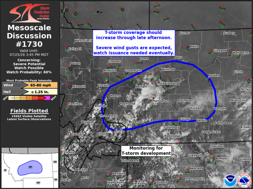
   Areas affected...Central Montana

   Concerning...Severe potential...Watch possible

   Valid 251950Z - 252145Z

   Probability of Watch Issuance...60 percent

   SUMMARY...Thunderstorm coverage and the potential for severe wind
   gusts will increase over the next several hours across central
   Montana. Watch issuance is probable.

   DISCUSSION...Early attempts at sustained deep convection have been
   evident across southwest to central MT over the past several hours.
   Lingering inhibition has largely limited storm longevity and
   intensity thus far; however, downstream of this activity
   temperatures are slowly warming into the mid to upper 90s. While
   some lingering inhibition likely persists, further heating over the
   next few hours should erode inhibition and increase the likelihood
   of sustained convection away from the terrain. Recent GOES imagery
   shows a gradual uptick in cumulus across parts of ID and southwest
   MT, hinting that thunderstorm coverage will likely increase in the
   next 2-3 hours.

   As thunderstorms spread east into the hotter and more deeply mixed
   air mass, the potential for severe winds will increase (especially
   for areas that have not been adversely impacted by outflow from
   recently decayed convection). Given some degree of stronger
   mid-level flow (30-35 knots near 500 mb per RAP analyses and
   forecast soundings), loosely organized clusters appear possible, and
   may be capable of producing wind gusts between 65-80 mph. Convective
   trends will continue to be monitored, and watch issuance may be
   needed when more widespread thunderstorm development becomes
   imminent.

   ..Moore/Smith.. 07/25/2026

   ...Please see www.spc.noaa.gov for graphic product...

   ATTN...WFO...BYZ...GGW...TFX...MSO...

   LAT...LON   46641229 46981201 47810953 47920867 47780768 47540722
               47220680 46860658 46420653 46080665 45850698 45790733
               45780793 45810849 45810911 45740976 45651016 45511080
               45451136 45431174 45521204 45721228 46251240 46641229

   MOST PROBABLE PEAK WIND GUST...65-80 MPH
   MOST PROBABLE PEAK HAIL SIZE...UP TO 1.25 IN
|
|
|
Top/All Mesoscale Discussions/Forecast Products/Home |
|
Source link