

| Mesoscale Discussion 1729 | |
| < Previous MD | |

|
|
   Mesoscale Discussion 1729
   NWS Storm Prediction Center Norman OK
   0215 PM CDT Sat Jul 25 2026

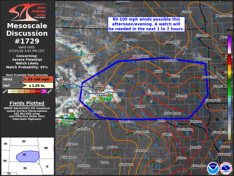
   Areas affected...south-central to southeast South Dakota

   Concerning...Severe potential...Watch likely

   Valid 251915Z - 252045Z

   Probability of Watch Issuance...95 percent

   SUMMARY...80-100 mph winds are possible this afternoon and evening
   from south-central to southeast South Dakota. A severe thunderstorm
   watch will be needed in the next 1 to 2 hours.

   DISCUSSION...A very hot environment is in place across South Dakota
   with temperatures of 105 to 110F across southwest and south-central
   South Dakota. The 18Z UNR RAOB shows nearly 2500 J/kg MLCAPE. This
   may be somewhat artificially inflated by the low-level dewpoint
   profile, but even after modifying this to something more realistic,
   MLCAPE near 2000 J/kg seems likely. This is significantly less than
   SPC mesoanalysis but is more congruent with current satellite and
   radar imagery which show what appears to be surface-based storm
   development within areas that currently indicate significant
   remaining inhibition from SPC mesoanalysis.

   These storms are developing on the leading edge of a mid-upper level
   cirrus deck as ascent associated with a weak shortwave trough
   emerges over the Plains. Expect these storms to continue to increase
   in coverage, and considering the 50F temperature/dewpoint spreads,
   expect outflow dominant storms and a congealing cold pool. There is
   some uncertainty how the storms will evolve, but given the
   environment with a hot and unstable airmass to the west and very
   high moisture content to the east with moderate shear and very steep
   lapse rates, expect an MCS to develop with the potential for intense
   wind gusts (perhaps has high as 100 mph).

   A severe thunderstorm watch will be needed for this threat in the
   next 1 to 2 hours and a PDS severe thunderstorm watch may be
   considered.

   ..Bentley/Smith.. 07/25/2026

   ...Please see www.spc.noaa.gov for graphic product...

   ATTN...WFO...FSD...ABR...LBF...UNR...

   LAT...LON   44170221 44900061 45029856 44819662 43819654 43379694
               43039743 42990042 43050140 43580230 44170221

   MOST PROBABLE PEAK WIND GUST...85-100 MPH
   MOST PROBABLE PEAK HAIL SIZE...UP TO 1.25 IN
|
|
|
Top/All Mesoscale Discussions/Forecast Products/Home |
|
Source link