

| Mesoscale Discussion 1719 | |
| < Previous MD | |

|
|
   Mesoscale Discussion 1719
   NWS Storm Prediction Center Norman OK
   1058 PM CDT Thu Jul 23 2026

   Areas affected...portions of north-central into northeastern Kansas

   Concerning...Severe potential...Watch unlikely

   Valid 240358Z - 240500Z

   Probability of Watch Issuance...5 percent

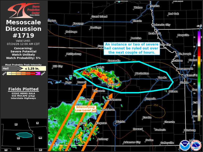
   SUMMARY...An instance or two of severe hail may accompany one of the
   stronger storms over the next couple of hours. However, any severe
   threat that manages to materialize should remain sparse and short
   lived.

   DISCUSSION...Convection has gradually intensified along the terminus
   of a strengthening low-level jet, where 850 mb warm-air-advection
   and isentropic ascent are maximized. Latest MRMS mosaic MESH data
   suggests that some of the stronger embedded cells may be producing
   hail approaching severe criteria. Nonetheless, as these storms
   progress eastward, they should zonally outpace the low-level jet
   axis and accompanying MUCAPE field (exceeding 500 J/kg). Therefore,
   the expectation is for the severe hail threat to remain sparse at
   best, as well as short lived.

   ..Squitieri/Mosier.. 07/24/2026

   ...Please see www.spc.noaa.gov for graphic product...

   ATTN...WFO...EAX...TOP...ICT...GID...

   LAT...LON   39289897 39539800 39599639 39259531 38949507 38759525
               38699585 38639643 38649711 38839806 39289897

   MOST PROBABLE PEAK HAIL SIZE...UP TO 1.25 IN
|
|
|
Top/All Mesoscale Discussions/Forecast Products/Home |
|
Source link