

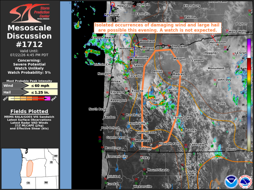
| Mesoscale Discussion 1712 | |
| < Previous MD | |

|
|
   Mesoscale Discussion 1712
   NWS Storm Prediction Center Norman OK
   0448 PM CDT Wed Jul 22 2026

   Areas affected...Oregon Cascades into western parts of the Blue
   Mountains

   Concerning...Severe potential...Watch unlikely

   Valid 222148Z - 222345Z

   Probability of Watch Issuance...5 percent

   SUMMARY...Isolated severe storm potential will increase across the
   area late this afternoon into evening. Marginally severe hail and
   locally damaging wind gusts are possible; however, the areal
   coverage is expected to remain too limited to warrant a watch
   issuance.

   DISCUSSION...Radar and satellite trends show thunderstorms
   developing over the Cascades and locations to the immediate east in
   response to the glancing influence of a subtle mid-level disturbance
   moving nearer to the coast. Strong daytime heating has led to
   temperatures in the upper 80s to upper 90s east of the high terrain,
   which, coupled with dewpoints in the 40s to low 50s and modestly
   steep mid-level lapse rates, is resulting in pockets of MLCAPE
   approaching 1000 J/kg.

   The strongest mid-level winds and resultant vertical shear reside
   over western OR with around 30 kt of effective bulk shear analyzed
   across the Cascades. That slight shear enhancement coupled with the
   locally steeper mid-level lapse rates will support marginally severe
   hail potential over the high terrain this afternoon into evening.
   Farther east, a deeper, well-mixed boundary layer will favor latent
   cooling processes in the sub-cloud layer, leading to the potential
   for a few damaging wind gusts.

   ..Mead/Mosier.. 07/22/2026

   ...Please see www.spc.noaa.gov for graphic product...

   ATTN...WFO...PDT...MFR...PQR...

   LAT...LON   42872253 44042256 44982246 45512192 45552119 45002068
               43332087 42392134 42122197 42202254 42872253

   MOST PROBABLE PEAK WIND GUST...UP TO 60 MPH
   MOST PROBABLE PEAK HAIL SIZE...UP TO 1.25 IN
|
|
|
Top/All Mesoscale Discussions/Forecast Products/Home |
|
Source link