

| Mesoscale Discussion 1710 | |
| < Previous MD Next MD > | |

|
|
   Mesoscale Discussion 1710
   NWS Storm Prediction Center Norman OK
   0313 PM CDT Wed Jul 22 2026

   Areas affected...portions of southeast Texas

   Concerning...Severe potential...Watch possible

   Valid 222013Z - 222215Z

   Probability of Watch Issuance...40 percent

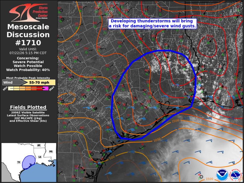
   SUMMARY...Thunderstorm development is expected across southeast
   Texas over the next 1-2 hours, with southwestward-moving storms
   bringing a threat for damaging/severe wind gusts.

   DISCUSSION...Latest surface observations indicate that temperatures
   have warmed to near 100 F amid dewpoints in the mid-to-upper 70s F
   across southeast Texas and southwestern Louisiana. Satellite imagery
   depicts a deepening cumulus field along a weak confluence zone with
   recent lightning activity noted. While mid-level lapse rates remain
   poor, hot and humid conditions are supporting strong buoyancy
   (MLCAPE of 3500 J/kg sampled by the 18z LCH observed sounding), and
   further heating will support thunderstorm development within this
   environment over the next 1-2 hours. Deep-layer northeasterly flow
   and enhanced effective shear along the western periphery of Tropical
   Storm Bertha will favor a cluster or two of southwestward
   propagating thunderstorms, with well-mixed boundary layer profiles
   (observed dewpoint depressions of around 25 F), very high PW (2.55
   inches sampled by the LCH sounding), and enhanced mid-level flow
   (35-45+ kts sampled at 3-4 km AGL by the LCH/POE VAD profiles)
   supporting a risk for damaging/severe wind gusts. Consideration may
   be given to a targeted Severe Thunderstorm Watch pending the
   development of a stronger cluster or two.

   ..Chalmers/Thompson.. 07/22/2026

   ...Please see www.spc.noaa.gov for graphic product...

   ATTN...WFO...LCH...SHV...HGX...FWD...CRP...EWX...

   LAT...LON   31339419 31219402 30949381 30599368 30309370 30039371
               29599387 29319455 28929513 28579571 28519603 28569648
               28789670 29309685 29959682 30679644 31069608 31359556
               31449515 31449465 31339419

   MOST PROBABLE PEAK WIND GUST...55-70 MPH
|
|
|
Top/All Mesoscale Discussions/Forecast Products/Home |
|
Source link