| Mesoscale Discussion 1705 | |
| < Previous MD | |

|
|
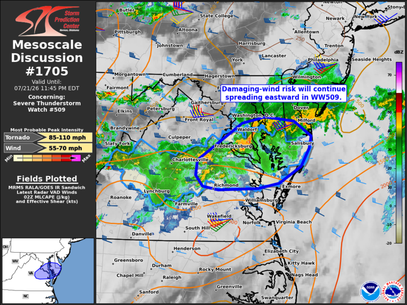
Mesoscale Discussion 1705 NWS Storm Prediction Center Norman OK 0939 PM CDT Tue Jul 21 2026 Areas affected...Portions of east-central VA...southern MD...and the Eastern Shore Concerning...Severe Thunderstorm Watch 509... Valid 220239Z - 220345Z The severe weather threat for Severe Thunderstorm Watch 509 continues. SUMMARY...The risk of damaging thunderstorm wind gusts will continue spreading eastward from east-central Virginia to the Eastern Shore tonight -- within Severe Thunderstorms Watch 509. DISCUSSION...The latest radar data from KLWX shows a north/south-oriented line segment tracking eastward across southern MD, with additional less-organized multicell clusters moving eastward across east-central VA. The primary severe risk will be associated with the line segment as it overspreads southern MD and the Eastern Shore over the next couple of hours, aided by an MCV, established cold pool, and around 45 kt of line-orthogonal 0-6 km shear (per LWX VWP). Given the linear mode, damaging gusts will continue to be the main concern. The storms farther south over east-central VA are generally in a less favorable air mass, though a robust low-level jet (40-50 kt sampled by AKQ VWP) impinging on the area will conditionally support embedded rotation and the potential for locally damaging gusts and a brief tornado for the next hour or so. ..Weinman.. 07/22/2026 ...Please see www.spc.noaa.gov for graphic product... ATTN...WFO...PHI...AKQ...LWX... LAT...LON 38097783 38807676 38927620 38847549 38557507 38327512 37987532 37657585 37557636 37537732 37607770 37807787 38097783 MOST PROBABLE PEAK TORNADO INTENSITY...85-110 MPH MOST PROBABLE PEAK WIND GUST...55-70 MPH |
|
|
Top/All Mesoscale Discussions/Forecast Products/Home |
|
Source link