| Mesoscale Discussion 1704 | |
| < Previous MD | |

|
|
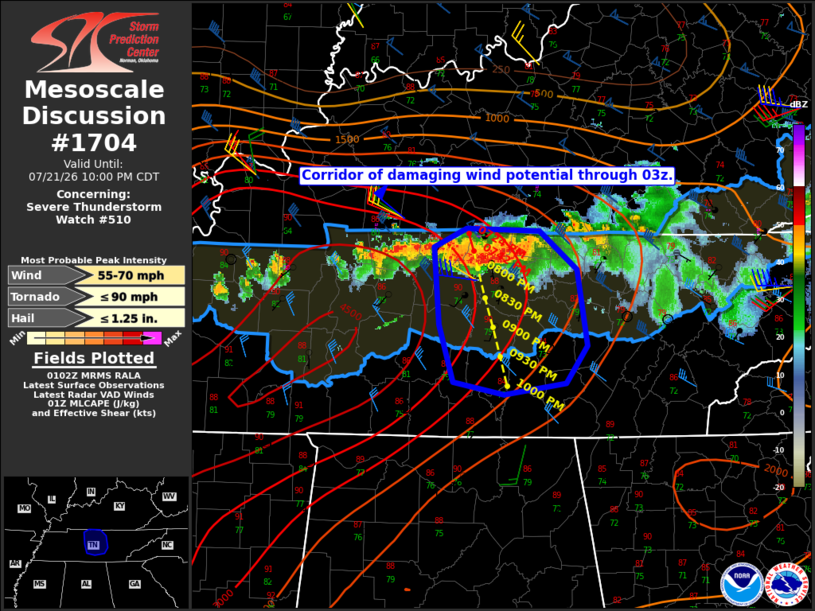
Mesoscale Discussion 1704 NWS Storm Prediction Center Norman OK 0804 PM CDT Tue Jul 21 2026 Areas affected...middle Tennessee Concerning...Severe Thunderstorm Watch 510... Valid 220104Z - 220300Z The severe weather threat for Severe Thunderstorm Watch 510 continues. SUMMARY...A corridor of greater damaging wind potential appears to be developing over middle Tennessee, including the Nashville metropolitan area. Gusts up to 60-70 mph appear possible. DISCUSSION...A line of intense storms has evolved over northern middle TN as of 01Z, with KOHX base data sampling periodic rear-inflow notches and channels of enhanced inbound winds. The 00Z BNA sounding is likely representative of the inflow environment, featuring MLCAPE approaching 3000 J/kg and around 40 kt of effective bulk shear, which is aligned largely perpendicular to the thunderstorm line. While low-level lapse rates aren't particularly steep, the high instability/high PW environment will promote water-loaded downdrafts capable of 60-70 mph wind gusts as the line develops south-southeast through middle TN. Extrapolation of current storm motion takes the line to the southern fringe of the watch area by 0230Z. The watch may need to be locally extended in area prior to that time. ..Mead.. 07/22/2026 ...Please see www.spc.noaa.gov for graphic product... ATTN...WFO...MRX...LMK...OHX...HUN... LAT...LON 35888692 36518698 36658666 36648594 36328556 35728547 35418567 35328629 35438679 35888692 MOST PROBABLE PEAK TORNADO INTENSITY...UP TO 90 MPH MOST PROBABLE PEAK WIND GUST...55-70 MPH MOST PROBABLE PEAK HAIL SIZE...UP TO 1.25 IN |
|
|
Top/All Mesoscale Discussions/Forecast Products/Home |
|
Source link