| Mesoscale Discussion 1702 | |
| < Previous MD Next MD > | |

|
|
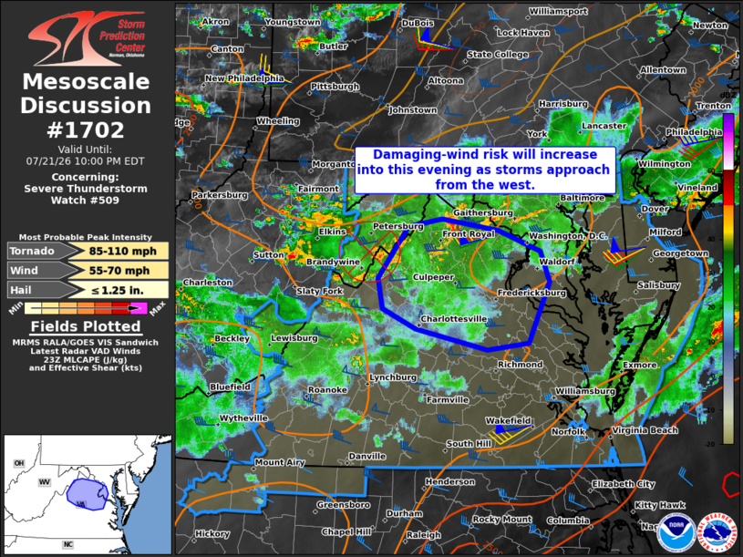
Mesoscale Discussion 1702 NWS Storm Prediction Center Norman OK 0657 PM CDT Tue Jul 21 2026 Areas affected...Portions of northern Virginia into southern Maryland Concerning...Severe Thunderstorm Watch 509... Valid 212357Z - 220200Z The severe weather threat for Severe Thunderstorm Watch 509 continues. SUMMARY...Thunderstorms approaching from the west will pose an increasing risk of damaging wind gusts and possibly a tornado or two across portions of northern Virginia this evening. DISCUSSION...A cluster of thunderstorms is crossing the high terrain of eastern WV and western VA this evening, aided by an MCV in Rockingham County VA. As these storms continue eastward across northern VA during the next few hours, a relatively warm and moist air mass and 40-50 kt of 0-6 km shear (per LWX VWP) may promote re-intensification into organized clusters and possibly supercell structures. This would favor an increasing risk of damaging wind gusts (especially if a north/south-oriented cold pool/gust front can evolve). Additionally, a gradually strengthening low-level jet and resultant increase in low-level hodograph curvature could support a brief tornado risk as well. Parts of Severe Thunderstorm Watch 509 may eventually need to be extended in time, or a new watch may be needed. ..Weinman.. 07/21/2026 ...Please see www.spc.noaa.gov for graphic product... ATTN...WFO...AKQ...LWX... LAT...LON 37767757 37987852 38197896 38517901 39067861 39137817 39027741 38797685 38477673 37837701 37767757 MOST PROBABLE PEAK TORNADO INTENSITY...85-110 MPH MOST PROBABLE PEAK WIND GUST...55-70 MPH MOST PROBABLE PEAK HAIL SIZE...UP TO 1.25 IN |
|
|
Top/All Mesoscale Discussions/Forecast Products/Home |
|
Source link