| Mesoscale Discussion 1700 | |
| < Previous MD | |

|
|
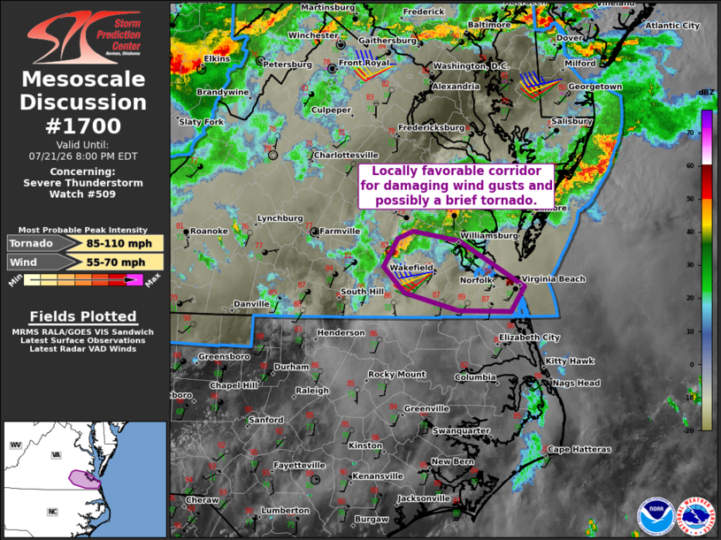
Mesoscale Discussion 1700 NWS Storm Prediction Center Norman OK 0527 PM CDT Tue Jul 21 2026 Areas affected...Parts of southeastern Virginia Concerning...Severe Thunderstorm Watch 509... Valid 212227Z - 220000Z The severe weather threat for Severe Thunderstorm Watch 509 continues. SUMMARY...A locally favorable corridor for damaging wind gusts and possibly a brief tornado is evident in southeastern Virginia for the next couple of hours. DISCUSSION...Along the southern edge of ongoing convection, a surface-based thunderstorm is evolving along an east/west-oriented differential heating zone in southeastern VA. Ahead of this activity, a warm/moist PBL (middle 70s dewpoints) is contributing to moderate surface-based buoyancy. This, combined with around 40 kt of 0-6 km shear and a clockwise-curved low-level hodograph (sampled by the AKQ VWP), is yielding a locally favorable corridor for organized clusters and supercell structures. The primary concern continues to be damaging wind gusts, though a brief tornado cannot be ruled out given the aforementioned low-level shear. ..Weinman.. 07/21/2026 ...Please see www.spc.noaa.gov for graphic product... ATTN...WFO...AKQ... LAT...LON 36617670 36787735 37037759 37307743 37367725 37277670 36837592 36607608 36617670 MOST PROBABLE PEAK TORNADO INTENSITY...85-110 MPH MOST PROBABLE PEAK WIND GUST...55-70 MPH |
|
|
Top/All Mesoscale Discussions/Forecast Products/Home |
|
Source link