

| Mesoscale Discussion 1696 | |
| < Previous MD Next MD > | |

|
|
   Mesoscale Discussion 1696
   NWS Storm Prediction Center Norman OK
   0323 PM CDT Tue Jul 21 2026

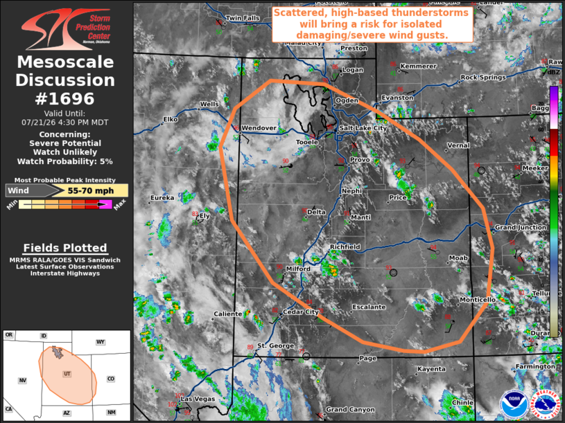
   Areas affected...portions of the eastern Great Basin

   Concerning...Severe potential...Watch unlikely

   Valid 212023Z - 212230Z

   Probability of Watch Issuance...5 percent

   SUMMARY...Scattered, high-based thunderstorms are expected this
   afternoon and evening across much of the Great Basin. Isolated
   damaging/severe wind gusts may occur with the strongest downdrafts.

   DISCUSSION...18z observed soundings from GJT/SLC depicted dry,
   increasingly well-mixed boundary layer profiles underlying steep
   mid-level lapse rates. Amid enhanced mid-level moisture and ahead of
   a weak mid-level perturbation along the western periphery of an
   upper-level ridge, convective coverage is forecast to increase
   through the afternoon as convective temperatures are breached.
   Inverted-v thermodynamic profiles with LCLs of 2.5-3.0+ km will
   promote efficient evaporative cooling and the potential for isolated
   damaging/severe wind gusts with downdrafts. The best potential for
   this risk may manifest from southeastern Utah/far western Colorado
   into central Utah where marginally stronger low-to-mid level flow
   (20-25 kts sampled by the GJX/ICX VWPs) and effective shear (20-25
   kts per latest objective analysis) may promote a loosely organized
   convective cluster or two. The threat for damaging/severe wind gusts
   is forecast to remain too isolated to warrant watch issuance at this
   time, however.

   ..Chalmers/Mosier.. 07/21/2026

   ...Please see www.spc.noaa.gov for graphic product...

   ATTN...WFO...GJT...SLC...LKN...

   LAT...LON   37651219 38241325 39261416 40481446 41131416 41611339
               41561219 41111100 40631010 40130941 39460876 38790857
               37900872 37250932 37091006 37111048 37251135 37651219

   MOST PROBABLE PEAK WIND GUST...55-70 MPH
|
|
|
Top/All Mesoscale Discussions/Forecast Products/Home |
|
Source link