| Mesoscale Discussion 1695 | |
| < Previous MD Next MD > | |

|
|
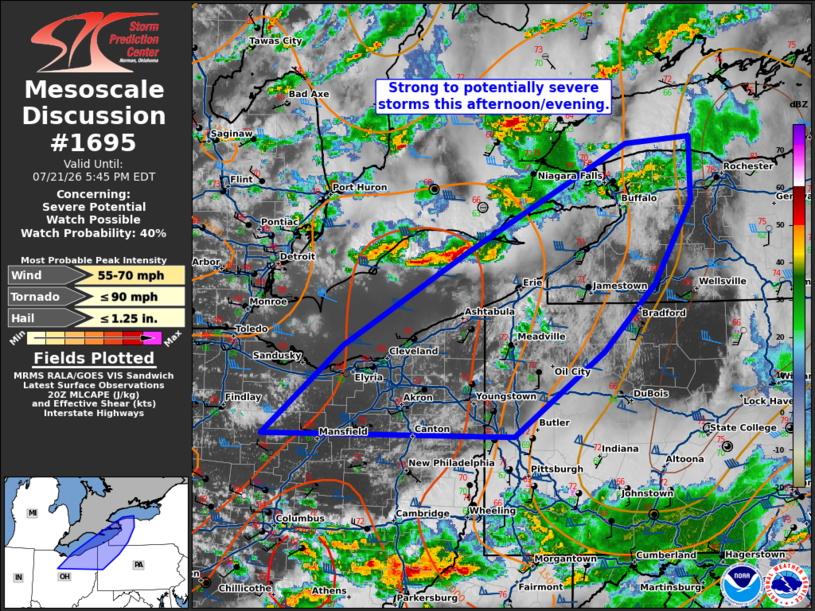
   Mesoscale Discussion 1695
   NWS Storm Prediction Center Norman OK
   0316 PM CDT Tue Jul 21 2026

   Areas affected...northeast Ohio and northwest Pennsylvania and
   western New York

   Concerning...Severe potential...Watch possible

   Valid 212016Z - 212145Z

   Probability of Watch Issuance...40 percent

   SUMMARY...Strong to severe storms are possible this afternoon and
   evening.

   DISCUSSION...Storms across southern Ontario will move eastward this
   afternoon toward western New York this evening. This area has seen
   cloud cover for most of the day, but as clouds are clearing, the
   environment is destabilizing rapidly from northeast Ohio into
   northwest Pennsylvania. It is unclear how far northeast the greater
   instability (1500+ J/kg MLCAPE) will extend ahead of the ongoing
   activity. However, if it can sufficiently destabilize, there may be
   some severe weather threat this evening across western New York and
   perhaps into northern Ohio with any additional development which may
   occur along the cold front.

   ..Bentley/Mosier.. 07/21/2026

   ...Please see www.spc.noaa.gov for graphic product...

   ATTN...WFO...BUF...CTP...PBZ...CLE...

   LAT...LON   40798318 41608221 42478071 43437878 43507801 42927799
               42177845 41567906 40798015 40798318

   MOST PROBABLE PEAK TORNADO INTENSITY...UP TO 90 MPH
   MOST PROBABLE PEAK WIND GUST...55-70 MPH
   MOST PROBABLE PEAK HAIL SIZE...UP TO 1.25 IN
|
|
|
Top/All Mesoscale Discussions/Forecast Products/Home |
|
Source link