| Mesoscale Discussion 1691 | |
| < Previous MD | |

|
|
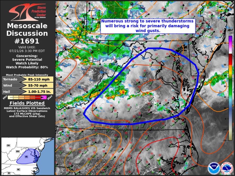
   Mesoscale Discussion 1691
   NWS Storm Prediction Center Norman OK
   1253 PM CDT Tue Jul 21 2026

   Areas affected...portions of the Mid-Atlantic

   Concerning...Severe potential...Watch likely

   Valid 211753Z - 211930Z

   Probability of Watch Issuance...80 percent

   SUMMARY...Multiple rounds of numerous, strong to severe
   thunderstorms will bring a risk for primarily damaging wind gusts to
   portions of the Mid-Atlantic through this evening, with a couple of
   brief tornadoes and isolated large hail also possible.

   DISCUSSION...Scattered thunderstorms have developed along the Blue
   Ridge as of 1750 UTC ahead of a mid-level shortwave trough that is
   progressing eastward across the upper Ohio Valley. Expectation is
   for this activity to spread eastward this afternoon with additional
   thunderstorms likely to progress into the region from the northwest
   this evening. Filtered heating of the downstream environment has
   resulted in temperatures warming into the upper 80s/near 90 F. With
   dewpoints in the low/mid 70s, this is supporting moderately strong
   buoyancy across the region. While effective shear of 35-45+ kts will
   favor storm organization, widespread thunderstorm development and
   cold pool consolidation are anticipated to yield a
   multicellular/outflow-dominant storm mode, with damaging to severe
   wind gusts the primary risk. A couple of brief tornadoes and
   isolated large hail will also be possible.

   Additionally, guidance suggests that air mass recovery will occur in
   the wake of these initial storms, which may allow the severe threat
   to persist into this evening as additional convection progresses
   southeastward into the region. Given this severe potential, watch
   issuance will likely be needed in the next hour or two.

   ..Chalmers/Mosier.. 07/21/2026

   ...Please see www.spc.noaa.gov for graphic product...

   ATTN...WFO...PHI...AKQ...LWX...RNK...

   LAT...LON   37348031 38057950 39047840 39467763 39467704 39397660
               39147596 38857550 38557536 38147544 37417580 37067629
               36927689 36917711 36747834 36737931 36818019 37078049
               37218043 37348031

   MOST PROBABLE PEAK TORNADO INTENSITY...85-110 MPH
   MOST PROBABLE PEAK WIND GUST...55-70 MPH
   MOST PROBABLE PEAK HAIL SIZE...1.00-1.75 IN
|
|
|
Top/All Mesoscale Discussions/Forecast Products/Home |
|
Source link