| Mesoscale Discussion 1685 | |
| < Previous MD | |

|
|
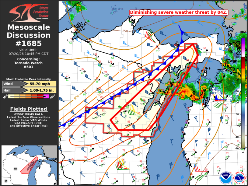
Mesoscale Discussion 1685 NWS Storm Prediction Center Norman OK 0952 PM CDT Mon Jul 20 2026 Areas affected...northeast Wisconsin Concerning...Tornado Watch 501... Valid 210252Z - 210345Z The severe weather threat for Tornado Watch 501 continues. SUMMARY...The severe weather threat is expected to diminish by 04Z, and an additional watch is not expected. DISCUSSION...As of 0240Z, KGRB radar imagery showed the trailing extension of a broader thunderstorm complex over Green Bay and adjacent Door County, to the east of a weak surface front moving into the area from the northwest. Both the KGRB and KMKX VWPs indicate a gradual veering and strengthening of the low-level jet with the strongest warm advection and moisture flux occurring across Lake Michigan into lower MI. As such, the current expectation is that the severe weather risk will continue to spread east of the area through 04Z. It should be noted that some of the 00Z CAMs suggest the potential for isolated to widely scattered storm development in the 02-04Z timeframe across eastern WI, so convective trends are being monitored for that scenario. ..Mead.. 07/21/2026 ...Please see www.spc.noaa.gov for graphic product... ATTN...WFO...APX...MQT...GRB... LAT...LON 44348932 45348788 46178660 46498601 46178581 44508732 44078782 44068901 44348932 MOST PROBABLE PEAK WIND GUST...55-70 MPH MOST PROBABLE PEAK HAIL SIZE...1.00-1.75 IN |
|
|
Top/All Mesoscale Discussions/Forecast Products/Home |
|
Source link