| Mesoscale Discussion 1684 | |
| < Previous MD | |

|
|
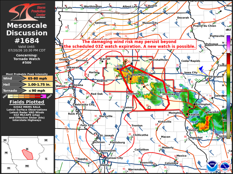
Mesoscale Discussion 1684 NWS Storm Prediction Center Norman OK 0907 PM CDT Mon Jul 20 2026 Areas affected...central Iowa Concerning...Tornado Watch 500... Valid 210207Z - 210330Z The severe weather threat for Tornado Watch 500 continues. SUMMARY...The damaging wind risk may persist beyond the scheduled 03Z watch expiration. A new severe thunderstorm watch is possible. DISCUSSION...A cold-pool-driven storm complex was located over Des Moines as of 0155Z with KDMX base velocities indicating outbound values in excess of 50 kt on the south side of the metropolitan area. Environmentally, low-level lapse rates are gradually weakening with no indication of a rear-inflow jet in the KDMX VWP. Nonetheless, the presence of seasonably strong vertical shear and residual moderate instability, per latest objective analysis, suggests that the risk for damaging winds may persist beyond the scheduled 03Z expiration of the watch. As such, convective trends are being monitored for the possibility of a new severe thunderstorm watch or a local extension of the existing watch. ..Mead.. 07/21/2026 ...Please see www.spc.noaa.gov for graphic product... ATTN...WFO...DVN...DMX... LAT...LON 40619305 41239371 41809406 41959369 41469234 40789211 40619228 40619305 MOST PROBABLE PEAK TORNADO INTENSITY...UP TO 90 MPH MOST PROBABLE PEAK WIND GUST...65-80 MPH MOST PROBABLE PEAK HAIL SIZE...1.00-1.75 IN |
|
|
Top/All Mesoscale Discussions/Forecast Products/Home |
|
Source link