| Mesoscale Discussion 1683 | |
| < Previous MD | |

|
|
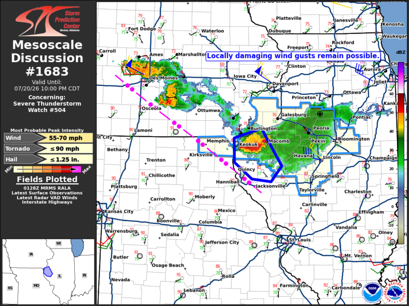
Mesoscale Discussion 1683 NWS Storm Prediction Center Norman OK 0830 PM CDT Mon Jul 20 2026 Areas affected...west-central Illinois Concerning...Severe Thunderstorm Watch 504... Valid 210130Z - 210300Z The severe weather threat for Severe Thunderstorm Watch 504 continues. SUMMARY...The potential for locally damaging wind gusts will continue and may develop south of the watch area. Convective trends are being monitored for a possible downstream watch. DISCUSSION...As of 0115Z, a small cluster of thunderstorms was centered over Hancock and McDonough Counties, IL, with a system motion of 325/25 kt. While distant from the radar, base velocity data from KDVN show 60+ kt outbound values at ~7 kft above the ground. Latest objective fields indicate poor low-level lapse rates and increasing convective inhibition, which are likely limiting the potential for the stronger winds aloft from reaching the ground. These factors are expected to limit the potential for a more robust damaging wind threat; however, isolated wind gusts of 60-65 mph will remain possible for the next several hours. ..Mead.. 07/21/2026 ...Please see www.spc.noaa.gov for graphic product... ATTN...WFO...ILX...LSX...DVN... LAT...LON 39829105 40139147 40589147 40769081 40069032 39779059 39829105 MOST PROBABLE PEAK TORNADO INTENSITY...UP TO 90 MPH MOST PROBABLE PEAK WIND GUST...55-70 MPH MOST PROBABLE PEAK HAIL SIZE...UP TO 1.25 IN |
|
|
Top/All Mesoscale Discussions/Forecast Products/Home |
|
Source link