| Mesoscale Discussion 1675 | |
| < Previous MD | |

|
|
Mesoscale Discussion 1675
NWS Storm Prediction Center Norman OK
0248 PM CDT Mon Jul 20 2026
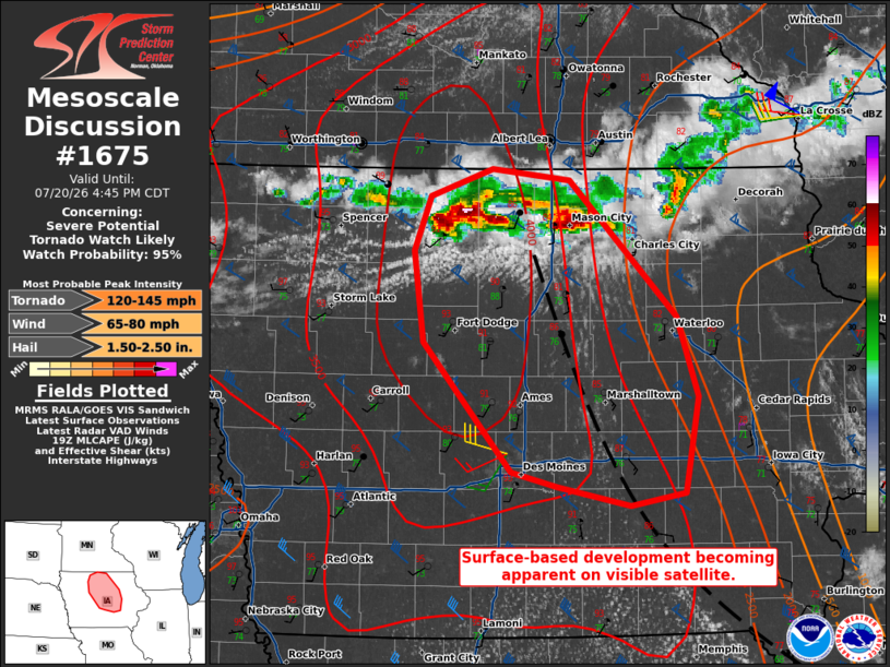
Areas affected...Portions of central Iowa
Concerning...Severe potential...Tornado Watch likely
Valid 201948Z - 202145Z
Probability of Watch Issuance...95 percent
SUMMARY...Storms in north-central Iowa are becoming surface based.
The environment is favorable for all severe hazards, including some
significant. A tornado watch is likely this afternoon for portions
of central Iowa.
DISCUSSION...Visible satellite imagery over the last half hour
suggest storms are becoming surface based in north-central Iowa.
Given the very unstable and strongly sheared environment to the
south of these storms, storms will likely become severe this
afternoon. The presence of a modifying outflow boundary will provide
enhancement to low-level shear. Tornadoes, some potentially strong,
will be possible. Large to very-large hail will also be a concern
given the strong buoyancy and steep mid-level lapse rates. Severe
wind gusts could remain isolated in the short term with a
supercellular mode, but could become more prevalent with time as
clustering occurs. A tornado watch is likely this afternoon.
..Wendt/Thompson.. 07/20/2026
...Please see www.spc.noaa.gov for graphic product...
ATTN...WFO...DVN...ARX...DMX...
LAT...LON 41609368 42419442 42999451 43339437 43499384 43429320
42589229 42079212 41479223 41399268 41529331 41609368
MOST PROBABLE PEAK TORNADO INTENSITY...120-145 MPH
MOST PROBABLE PEAK WIND GUST...65-80 MPH
MOST PROBABLE PEAK HAIL SIZE...1.50-2.50 IN
|
|
|
Top/All Mesoscale Discussions/Forecast Products/Home |
|
Source link