| Mesoscale Discussion 1673 | |
| < Previous MD | |

|
|
Mesoscale Discussion 1673
NWS Storm Prediction Center Norman OK
1220 PM CDT Mon Jul 20 2026
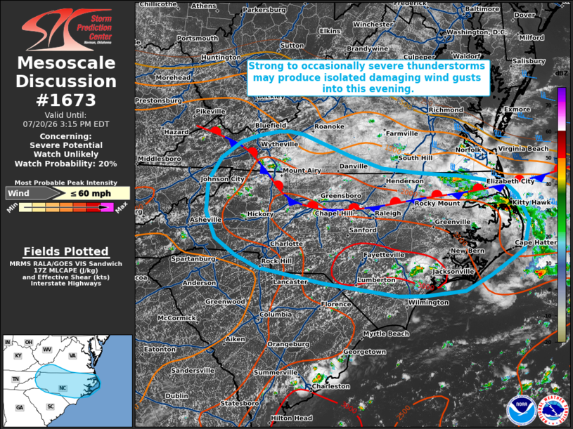
Areas affected...portions of far southern Virginia into much of
North Carolina
Concerning...Severe potential...Watch unlikely
Valid 201720Z - 201915Z
Probability of Watch Issuance...20 percent
SUMMARY...Strong to occasionally severe thunderstorms may produce
isolated damaging wind gusts through this evening.
DISCUSSION...Hot and humid conditions remain in place across much of
North Carolina and portions of Virginia in the vicinity of a
stationary surface front that extends roughly west-to-east across
northern NC. As surface temperatures increase amid continued diurnal
heating over the next couple of hours, scattered thunderstorm
initiation is expected along the Blue Ridge, the surface front, and
outflow/sea breeze boundaries near the coast. Similar to yesterday,
an outflow-dominant storm mode is likely given that deep-layer flow
remains fairly week. However, 20-25 kts of mid-level flow sampled by
regional VWPs may aid in marginal storm organization across the
region. In conjunction with steepening low-level lapse rates, a
moderately to strongly unstable environment, and high PW, this will
support a risk for water-loaded downbursts capable of occasionally
damaging wind gusts. Locally greater potential may develop across
portions of the NC Coastal Plain where the best overlap of
thermodynamic parameters is expected. Watch issuance appears
unlikely at this time, but a targeted Severe Thunderstorm Watch
could be considered should a corridor of greater severe potential
become apparent.
..Chalmers/Thompson.. 07/20/2026
...Please see www.spc.noaa.gov for graphic product...
ATTN...WFO...AKQ...MHX...RAH...ILM...RNK...CAE...GSP...MRX...
LAT...LON 36487682 36437642 36357581 36137556 35687532 35177544
34757615 34487669 34407756 34417812 34637971 34908108
35118156 35398199 35848218 36378216 36788188 37068145
37188106 37258065 37258040 37218011 37087976 36837909
36627844 36567781 36527732 36487682
MOST PROBABLE PEAK WIND GUST...UP TO 60 MPH
|
|
|
Top/All Mesoscale Discussions/Forecast Products/Home |
|
Source link