| Mesoscale Discussion 1668 | |
| < Previous MD | |

|
|
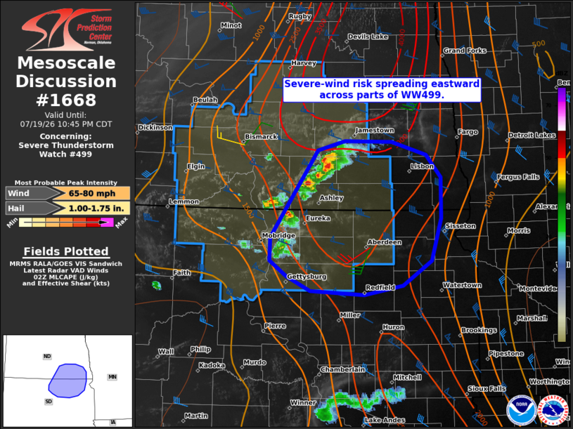
Mesoscale Discussion 1668 NWS Storm Prediction Center Norman OK 0912 PM CDT Sun Jul 19 2026 Areas affected...south-central/southeast ND and north-central/northeast SD Concerning...Severe Thunderstorm Watch 499... Valid 200212Z - 200345Z The severe weather threat for Severe Thunderstorm Watch 499 continues. SUMMARY...The risk of severe wind gusts will continue spreading eastward across parts of Severe Thunderstorm Watch 499. Some severe risk may extend eastward out of the watch, and convective trends are being monitored. DISCUSSION...The latest radar data from KBIS indicates some signs of a consolidating cold pool as storms continue spreading eastward across south-central ND and north-central SD. In the near-term, isolated severe hail and locally damaging gusts are the primary concerns with an evolving cluster and splitting cells. The ABR 00Z sounding sampled steep midlevel lapse rates atop a warm and very moist PBL (middle 70s dewpoints), resulting in a strongly unstable downstream air mass. This, combined with around 50 kt of effective shear oriented perpendicular to the evolving gust front, could support a continued risk of severe wind gusts east of Severe Thunderstorm Watch 499. However, some lingering low-level inhibition in the ABR sounding and a gradual increase in nocturnal static stability may temper the overall risk. Current thinking is that a downstream watch will not be needed, though convective trends are being monitored. ..Weinman/Hart.. 07/20/2026 ...Please see www.spc.noaa.gov for graphic product... ATTN...WFO...FGF...ABR...BIS... LAT...LON 46709937 46839887 46819800 46649736 46369709 45829709 45289727 44969780 44849852 44899950 45079994 45270025 45580025 46709937 MOST PROBABLE PEAK WIND GUST...65-80 MPH MOST PROBABLE PEAK HAIL SIZE...1.00-1.75 IN |
|
|
Top/All Mesoscale Discussions/Forecast Products/Home |
|
Source link