| Mesoscale Discussion 1665 | |
| < Previous MD | |

|
|
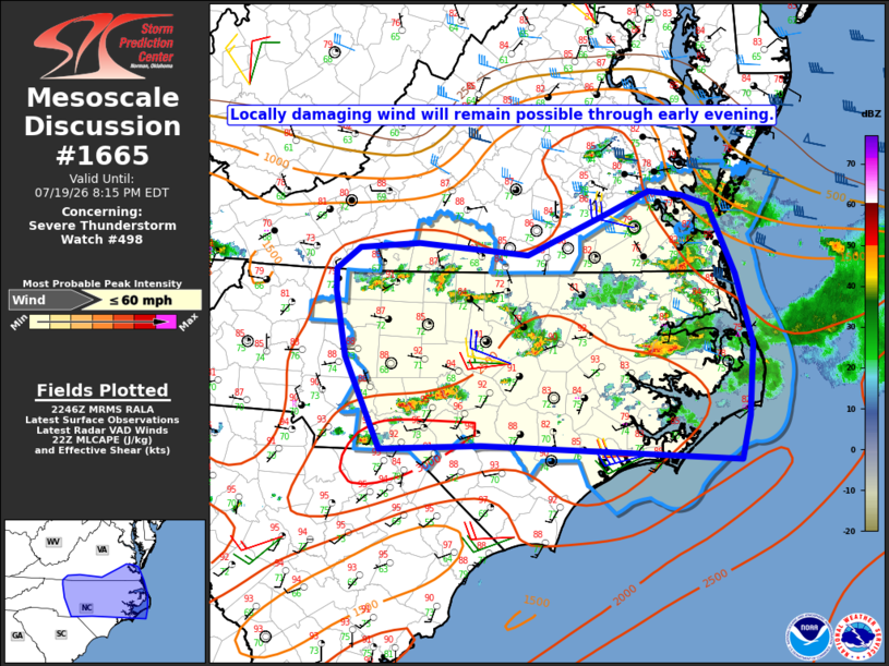
Mesoscale Discussion 1665 NWS Storm Prediction Center Norman OK 0548 PM CDT Sun Jul 19 2026 Areas affected...Parts of NC and southern VA Concerning...Severe Thunderstorm Watch 498... Valid 192248Z - 200015Z The severe weather threat for Severe Thunderstorm Watch 498 continues. SUMMARY...Locally damaging wind remains possible through early evening. DISCUSSION...Widely scattered storms are ongoing across parts of NC into far southern VA. With MLCAPE of 2000-3000 J/kg and large PW in place, occasionally vigorous updrafts and subsequent downdrafts will remain possible through early evening. However, the widely scattered storm coverage and lack of sustained storm clustering has limited coverage of the damaging-wind threat thus far. The most favorable effective shear (25-35 kt) resides across southern VA into northeast NC, though storms have remained isolated across these areas. While coverage may remain rather sparse in this area, any new or ongoing cells may be able to persist through the early evening with a threat of localized damaging wind. Farther south, the weaker shear will continue to result in more of a pulse character to storm development/evolution, though the large PW will support potential for wet microbursts. A gradual decrease in the severe wind threat is expected with time through the evening. However, nocturnal cooling/stabilization will be slow within the very moist environment, and a localized wind-damage threat may persist beyond the 00 UTC expiration time of WW 498. ..Dean.. 07/19/2026 ...Please see www.spc.noaa.gov for graphic product... ATTN...WFO...AKQ...MHX...RAH...ILM...RNK...GSP... LAT...LON 34727575 34857882 34818003 35708044 36348057 36558057 36778029 36817957 36717828 37127729 37327683 37297644 37197612 36527580 35847559 35147564 34727575 MOST PROBABLE PEAK WIND GUST...UP TO 60 MPH |
|
|
Top/All Mesoscale Discussions/Forecast Products/Home |
|
Source link