

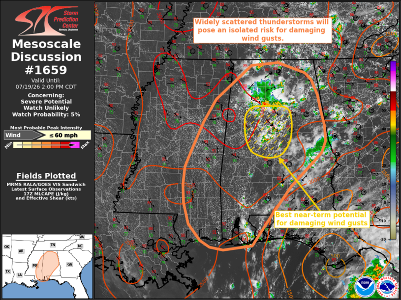
| Mesoscale Discussion 1659 | |
| < Previous MD | |

|
|
   Mesoscale Discussion 1659
   NWS Storm Prediction Center Norman OK
   1202 PM CDT Sun Jul 19 2026

   Areas affected...portions of eastern Mississippi into much of
   Alabama and the far western Florida Panhandle

   Concerning...Severe potential...Watch unlikely

   Valid 191702Z - 191900Z

   Probability of Watch Issuance...5 percent

   SUMMARY...Widely scattered thunderstorms will pose an isolated risk
   for strong to occasionally damaging downburst wind gusts through
   this evening.

   DISCUSSION...Latest surface observations depict temperatures warming
   into the low-90s F amid rich moisture (dewpoints in the mid-70s F)
   across much of the Southeast. While mid-level lapse rates remain
   poor, these warm and humid conditions are contributing to 1500-2500+
   J/kg MLCAPE from coastal MS/AL northward toward the AL/TN border. PW
   near 2 inches and steepening low-level lapse rates will support a
   risk for water-loaded downbursts capable of isolated strong to
   occasionally damaging wind gusts. Locally greater potential will
   accompany any marginally more organized clusters that can develop
   along consolidated cold pools amid weak deep-layer flow (generally
   less than 15-20 kts of deep-layer flow sampled by regional VWPs). In
   the near-term, locally greater damaging wind potential may evolve
   across central Alabama downstream of a loosely organized cluster of
   thunderstorms that is currently propagating southward toward the
   Birmingham Metro. The overall severe risk is expected to remain too
   isolated for watch issuance.

   ..Chalmers/Thompson.. 07/19/2026

   ...Please see www.spc.noaa.gov for graphic product...

   ATTN...WFO...BMX...HUN...MOB...MEG...JAN...LIX...

   LAT...LON   31738633 31018691 30208751 30108837 30168877 30348906
               30768941 31298955 31778958 32228954 32618937 33388899
               33978862 34858753 34918671 34658587 34458568 34078549
               33668540 33288530 32878528 32578540 32248578 31738633

   MOST PROBABLE PEAK WIND GUST...UP TO 60 MPH
|
|
|
Top/All Mesoscale Discussions/Forecast Products/Home |
|
Source link