| Mesoscale Discussion 1645 | |
| < Previous MD | |

|
|
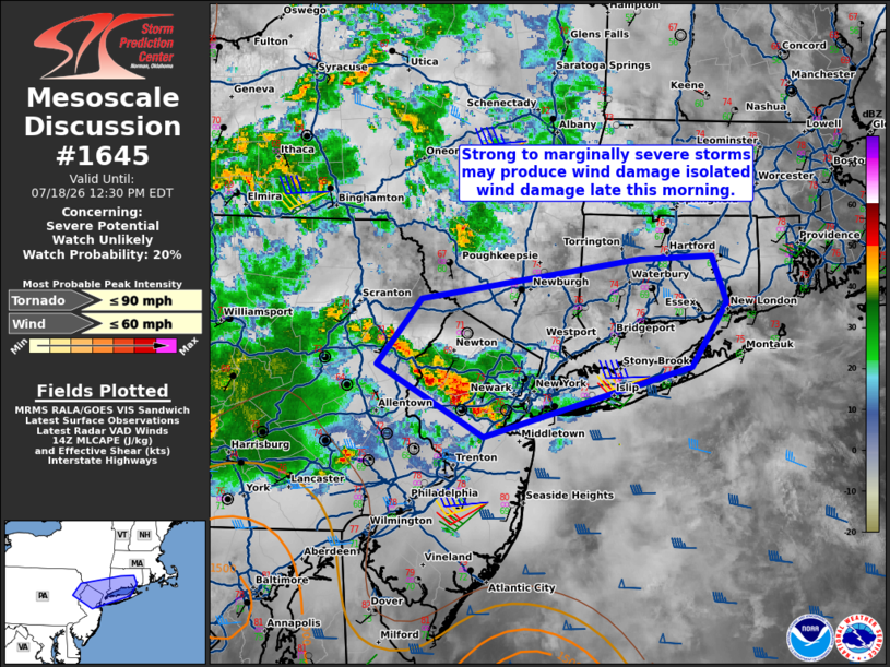
   Mesoscale Discussion 1645
   NWS Storm Prediction Center Norman OK
   1001 AM CDT Sat Jul 18 2026

   Areas affected...Northern Mid-Atlantic into southern New England

   Concerning...Severe potential...Watch unlikely

   Valid 181501Z - 181630Z

   Probability of Watch Issuance...20 percent

   SUMMARY...Isolated wind damage is possible with strong to marginally
   severe storms late this morning. A watch is not expected.

   DISCUSSION...A small linear cluster of storms has recently organized
   in northern New Jersey and adjacent northeast Pennsylvania. Storm
   cores have shown modest deepening on 7 km MRMS CAPPI over the last
   30 minutes. The observed OKX sounding had poor mid-level lapse rates
   (5.3 C/km) but 45 kt of effective shear. Downstream of this current
   activity, cloud cover and smoke have hindered surface heating.
   Low-level lapse rates are not expected to be overly steep. While
   isolated wind damage is possible late this morning, the severe
   threat should remain marginal on account of very limited buoyancy. A
   watch is not expected.

   ..Wendt/Thompson.. 07/18/2026

   ...Please see www.spc.noaa.gov for graphic product...

   ATTN...WFO...BOX...OKX...ALY...PHI...BGM...

   LAT...LON   40947548 41437505 41717294 41737225 41407211 40937244
               40417446 40947548

   MOST PROBABLE PEAK TORNADO INTENSITY...UP TO 90 MPH
   MOST PROBABLE PEAK WIND GUST...UP TO 60 MPH
|
|
|
Top/All Mesoscale Discussions/Forecast Products/Home |
|
Source link