| Mesoscale Discussion 1638 | |
| < Previous MD | |

|
|
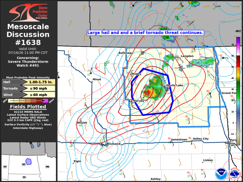
Mesoscale Discussion 1638 NWS Storm Prediction Center Norman OK 0925 PM CDT Thu Jul 16 2026 Areas affected...north-central North Dakota Concerning...Severe Thunderstorm Watch 491... Valid 170225Z - 170400Z The severe weather threat for Severe Thunderstorm Watch 491 continues. SUMMARY...The threat for large hail and a brief tornado or two continues across western portions of the watch area. DISCUSSION...As of 2:15Z, volumetric radar data indicates a supercell over southern Benson County moving at 325/20 kt. The storm has remained anchored to a boundary that extends to the south-southwest with a recent tornado report near Maddock. Latest objective analysis indicates 0-3-km CAPE as high as 150-175 J/kg along the boundary, and while low-level shear is not overly strong, the storm-boundary interaction will support a continued risk for a brief tornado or two for the next 1-2 hours. Despite echo tops approaching 65 kft at times, large hail has remained limited. However, given the persistent supercell structures, at least marginally severe hail will remain a threat. ..Mead.. 07/17/2026 ...Please see www.spc.noaa.gov for graphic product... ATTN...WFO...FGF...BIS... LAT...LON 47909996 48229997 48529960 48389878 47809862 47569874 47499960 47909996 MOST PROBABLE PEAK TORNADO INTENSITY...UP TO 90 MPH MOST PROBABLE PEAK WIND GUST...UP TO 60 MPH MOST PROBABLE PEAK HAIL SIZE...1.00-1.75 IN |
|
|
Top/All Mesoscale Discussions/Forecast Products/Home |
|
Source link