| Mesoscale Discussion 1624 | |
| < Previous MD | |

|
|
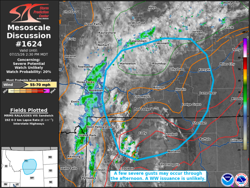
   Mesoscale Discussion 1624
   NWS Storm Prediction Center Norman OK
   0203 PM CDT Wed Jul 15 2026

   Areas affected...portions of southern Montana into northern Wyoming

   Concerning...Severe potential...Watch unlikely

   Valid 151903Z - 152030Z

   Probability of Watch Issuance...20 percent

   SUMMARY...A few severe gusts may occur with the stronger storms this
   afternoon. The severe threat should remain isolated, so a WW
   issuance is not expected.

   DISCUSSION...Strong surface heating (shown via observations of
   surface temperatures reaching the mid 80s F), and upslope flow, are
   encouraging scattered thunderstorm development across northern WY
   into southern MT. Despite poor tropospheric flow/shear in this
   region, 7-8 C/km lapse rates from the boundary layer through the
   free troposphere are contributing to enough instability to support
   strong pulse-cellular thunderstorm development through the
   afternoon. Given a deeply mixed boundary layer, evaporative cooling
   potential will support downbursts with heavier storm cores, the
   strongest of which may support a couple of severe gusts. Given the
   expected sparse nature of the severe threat, a Severe Thunderstorm
   Watch issuance is not expected.

   ..Squitieri/Mosier.. 07/15/2026

   ...Please see www.spc.noaa.gov for graphic product...

   ATTN...WFO...BYZ...GGW...RIW...TFX...

   LAT...LON   44000976 45111035 45541049 46291036 46840975 47200804
               47170694 46730632 46020607 45180635 44570686 44140753
               43970820 43830909 44000976

   MOST PROBABLE PEAK WIND GUST...55-70 MPH
|
|
|
Top/All Mesoscale Discussions/Forecast Products/Home |
|
Source link