| Mesoscale Discussion 1621 | |
| < Previous MD | |

|
|
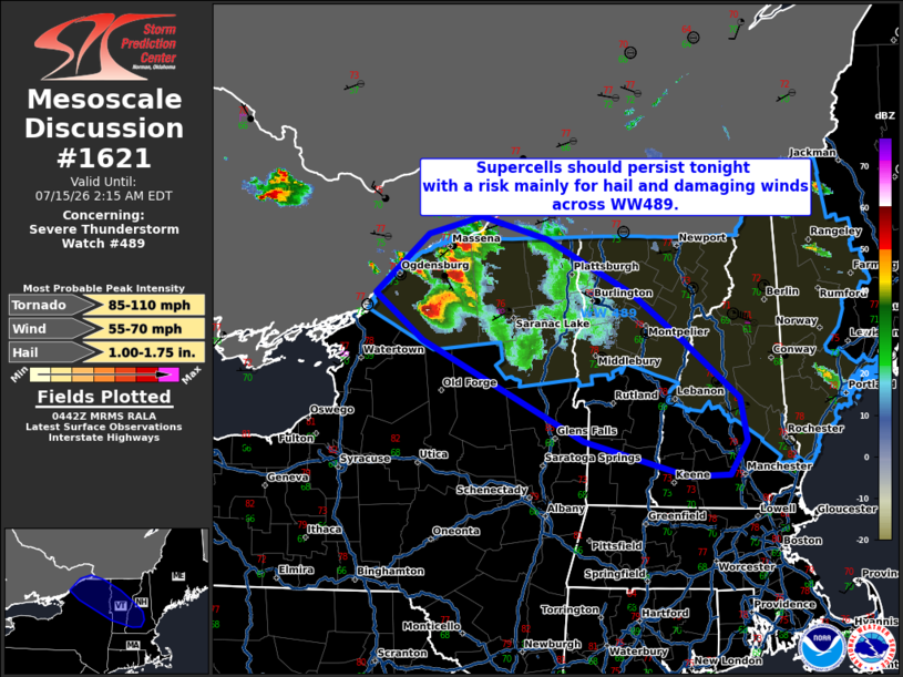
Mesoscale Discussion 1621 NWS Storm Prediction Center Norman OK 1144 PM CDT Tue Jul 14 2026 Areas affected...portions of northern New York into Vermont and New Hampshire. Concerning...Severe Thunderstorm Watch 489... Valid 150444Z - 150615Z The severe weather threat for Severe Thunderstorm Watch 489 continues. SUMMARY...Strong to severe storms are expected to persist across the western portions of WW489 into the overnight hours. Hail and damaging winds are the most likely hazards. DISCUSSION...As of 0440 UTC, a cluster of severe storms, including a robust supercell over St Lawrence County NY, are ongoing across western portions of WW489. Moderate buoyancy and strong deep-layer shear remain in place ahead of this convection, and new storm development just across the ON border. Hail is the most likely threat tonight, especially with the aforementioned supercell showing peak MRMS MESH of 2+ inches and a persistent cellular storm mode. Damaging winds are also possible with the stronger cells, though upscale growth appears limited given the very strong deep-layer shear. A tornado also cannot be ruled out given the ongoing supercells and strong vertical shear. With the favorable parameter space likely to persist tonight, severe potential should be maximized across parts of northern NY, into VT and southern NH. Storm should begin to weaken late tonight as they approach a more stable air mass into southern New England. ..Lyons.. 07/15/2026 ...Please see www.spc.noaa.gov for graphic product... ATTN...WFO...GYX...BTV...ALY... LAT...LON 44537274 44167218 43637149 43287141 42997161 42977210 43277331 44137519 44527574 45027513 45177451 44997374 44537274 MOST PROBABLE PEAK TORNADO INTENSITY...85-110 MPH MOST PROBABLE PEAK WIND GUST...55-70 MPH MOST PROBABLE PEAK HAIL SIZE...1.00-1.75 IN |
|
|
Top/All Mesoscale Discussions/Forecast Products/Home |
|
Source link