

| Mesoscale Discussion 1610 | |
| < Previous MD | |

|
|
   Mesoscale Discussion 1610
   NWS Storm Prediction Center Norman OK
   0727 PM CDT Sun Jul 12 2026

   Areas affected...portions of northeastern and eastern Montana

   Concerning...Severe potential...Watch unlikely

   Valid 130027Z - 130230Z

   Probability of Watch Issuance...5 percent

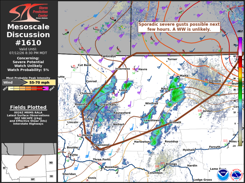
   SUMMARY...High-based showers and thunderstorms will be capable of
   sporadic severe gusts this evening, but a WW is unlikely.

   DISCUSSION...As of 0025 UTC, radar imagery shows high-based showers
   and storms have developed over parts of northern and eastern MT.
   Very hot surface temperatures (110+ F) are supporting very deep
   surface mixed layer depths of the order of 3-5 km. Within this deep
   dry boundary layer, dry adiabatic lapse rates and strong evaporation
   potential exist, which is supporting stronger downdrafts and dry
   microburst potential. Several mesonet stations have shown outflow
   gusts of45-55 kt so far. This should continue this evening, given
   the modest buoyancy (500-1000 J/kg MUCAPE) atop the deep and dry
   inverted v profiles.

   Broader storm organization potential appears limited however, owing
   to relatively modest buoyancy and dryness in the sub-cloud layer.
   While some clustering of stronger showers and outflow could develop
   as they move north toward the Canadian border where buoyancy is
   larger, a WW appears unlikely given the lack of more coherent
   convective organization.

   ..Lyons/Thompson.. 07/13/2026

   ...Please see www.spc.noaa.gov for graphic product...

   ATTN...WFO...BYZ...GGW...TFX...

   LAT...LON   47351203 48931016 49070973 49040499 47930620 47100805
               46491028 46251125 46591184 47351203

   MOST PROBABLE PEAK WIND GUST...55-70 MPH
|
|
|
Top/All Mesoscale Discussions/Forecast Products/Home |
|
Source link