| Mesoscale Discussion 1607 | |
| < Previous MD | |

|
|
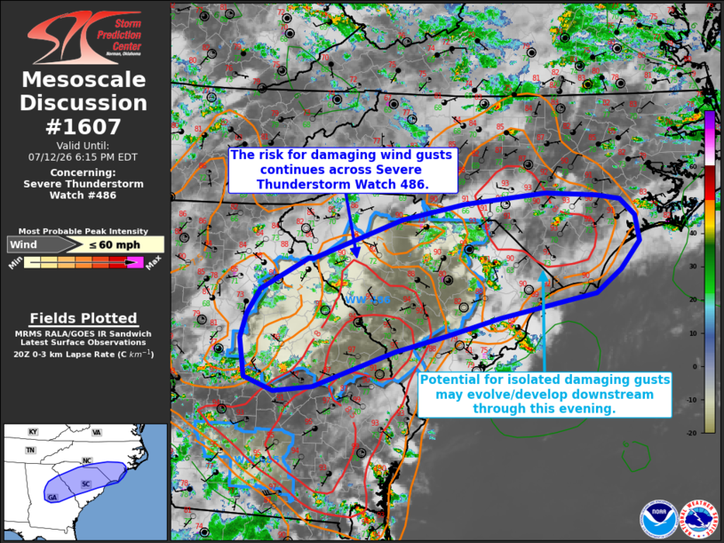
Mesoscale Discussion 1607 NWS Storm Prediction Center Norman OK 0346 PM CDT Sun Jul 12 2026 Areas affected...portions of central/eastern Georgia into central South Carolina Concerning...Severe Thunderstorm Watch 486... Valid 122046Z - 122215Z The severe weather threat for Severe Thunderstorm Watch 486 continues. SUMMARY...The potential for damaging wind gusts continues across Severe Thunderstorm Watch 486. Some potential for isolated damaging gusts may also develop/persist downstream into portions of northeastern SC/southeastern NC with time. DISCUSSION...Widely scattered thunderstorm activity continues across Severe Thunderstorm Watch 486 as of 2045 UTC, with isolated reports of damaging wind gusts noted over the past 1-2 hours. Continued heating of a moist low-level air mass continues to support moderately strong buoyancy (MLCAPE of 2000-2500 J/kg) and steep low-level lapse rates. This environment favors the continued potential for damaging wind gusts across the Watch area, particularly from eastern GA into western SC where low-level lapse rates are steeper. Latest objective analysis also depicts a zone of steeper low-level lapse rates across portions of southeastern NC. Convection evolving eastward from northern SC and/or additional thunderstorm development across the NC Coastal Plain may pose a risk for isolated damaging wind gusts through this evening, but downstream watch issuance appears unlikely at this time due to the expectation for this risk to remain isolated in nature. ..Chalmers/Smith.. 07/12/2026 ...Please see www.spc.noaa.gov for graphic product... ATTN...WFO...MHX...RAH...ILM...CHS...CAE...GSP...FFC... LAT...LON 33818361 34248281 34258273 34818124 35038019 35177882 35147795 35077755 34857730 34497724 34107756 33767798 33427960 33188051 32958135 32458270 32388336 32578384 33128393 33468382 33818361 MOST PROBABLE PEAK WIND GUST...UP TO 60 MPH |
|
|
Top/All Mesoscale Discussions/Forecast Products/Home |
|
Source link