| Mesoscale Discussion 1598 | |
| < Previous MD | |

|
|
Mesoscale Discussion 1598
NWS Storm Prediction Center Norman OK
0736 AM CDT Sun Jul 12 2026
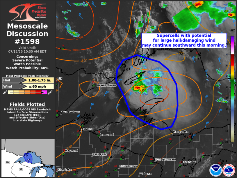
Areas affected...portions of the Upper Peninsula of Michigan
Concerning...Severe potential...Watch possible
Valid 121236Z - 121430Z
Probability of Watch Issuance...40 percent
SUMMARY...Supercells may track southward through the morning with
potential for large hail and damaging wind.
DISCUSSION...A supercell is tracking southward across Lake Superior
towards the Keweenaw Peninsula. There is some uncertainty in how far
south this storm will be sustained, as an additional supercell to
the north weakened quickly. Overnight guidance has handled the
evolution of these storms poorly, leading to low confidence in more
recent runs. The environment downstream has been steadily becoming
more unstable, with an EML advecting eastward across the region.
Currently, temperatures downstream of Lake Superior across the UP of
Michigan are cooler, in the upper 60s to 70s with decreasing
instability/deep layer shear to the south further inland. It is
possible that this initial wave of storms may weaken as they move
inland. Cumulus is deepening to the north of these initial cells
across southern Ontario, which may lead to additional thunderstorm
development over the next couple of hours. Trends will be monitored
but for now the severe potential appears to be isolated.
..Thornton/Gleason.. 07/12/2026
...Please see www.spc.noaa.gov for graphic product...
ATTN...WFO...MQT...DLH...
LAT...LON 47488921 47948957 48238953 48478931 48608876 48428788
48238753 47838722 47588719 47278718 46968724 46738742
46658782 46878853 47048892 47138902 47488921
MOST PROBABLE PEAK WIND GUST...UP TO 60 MPH
MOST PROBABLE PEAK HAIL SIZE...1.00-1.75 IN
|
|
|
Top/All Mesoscale Discussions/Forecast Products/Home |
|
Source link