| Mesoscale Discussion 1581 | |
| < Previous MD | |

|
|
Mesoscale Discussion 1581
NWS Storm Prediction Center Norman OK
0537 PM CDT Fri Jul 10 2026
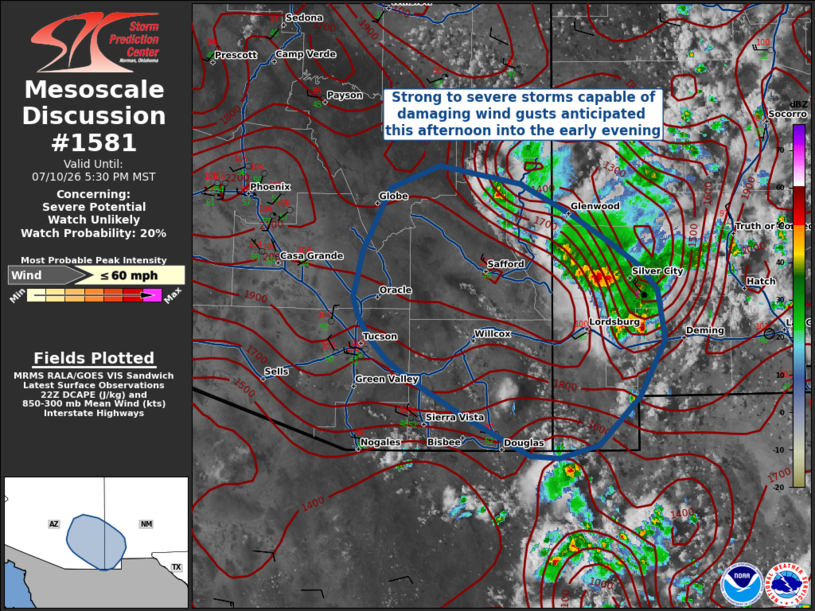
Areas affected...Southeastern Arizona into far southwestern New
Mexico
Concerning...Severe potential...Watch unlikely
Valid 102237Z - 110030Z
Probability of Watch Issuance...20 percent
SUMMARY...Thunderstorms have begun to move off the higher terrain
and into portions of southwestern New Mexico/southeastern Arizona.
These high-based monsoonal thunderstorms will be capable of some
damaging wind gusts approaching 60 MPH.
DISCUSSION...Current radar trends show convection moving
west-southwest off the higher terrain and into the lower desert
portions of southeastern Arizona and far southwestern New Mexico,
where HRRR-based mesoanalsysis indicates a modest amount of buoyancy
(~1000 J/kg) should support continued convective activity late this
afternoon into the evening. The 18Z soundings and 2142 UTC
aircraft-based sounding from Phoenix show hot, dry, and deeply-mixed
boundary layers in advance of these storms. As a result, these
storms could be capable of damaging wind gusts around 60 MPH --
particularly with the strongest downdraft cores, or along any
interacting outflows. Conditions will continue to be monitored for
potential watch issuance.
..Halbert/Thompson.. 07/10/2026
...Please see www.spc.noaa.gov for graphic product...
ATTN...WFO...ABQ...EPZ...TWC...FGZ...PSR...
LAT...LON 33521064 33711016 33550936 33310887 33070847 32880820
32660801 32250793 31780819 31380859 31260897 31290926
31600989 31921043 32081067 32271084 32441095 32611101
32991091 33521064
MOST PROBABLE PEAK WIND GUST...UP TO 60 MPH
|
|
|
Top/All Mesoscale Discussions/Forecast Products/Home |
|
Source link