

| Mesoscale Discussion 1571 | |
| < Previous MD | |

|
|
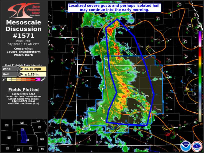
Mesoscale Discussion 1571 NWS Storm Prediction Center Norman OK 1144 PM CDT Thu Jul 09 2026 Areas affected...Southwest/south-central NE into western/central KS Concerning...Severe Thunderstorm Watch 478... Valid 100444Z - 100615Z The severe weather threat for Severe Thunderstorm Watch 478 continues. SUMMARY...Localized severe gusts and perhaps isolated hail may continue into the early morning. DISCUSSION...A convective line with a history of producing severe gusts has shown recent signs of weakening across western KS. With increasing CINH downstream into central KS, a notable uptick in storm organization is not currently anticipated. However, given the presence of a relatively well established cold pool and rear-inflow jet (noted on the KGLD VWP), strong to localized severe gusts will remain possible until a more definitive weakening trend occurs. Farther north, merging outflows have resulted in storm intensification near North Platte. Isolated hail may continue to be a threat in the short term with this storm, while localized strong to severe gusts may eventually spread into south-central NE, where moderate buoyancy remains in place. ..Dean.. 07/10/2026 ...Please see www.spc.noaa.gov for graphic product... ATTN...WFO...ICT...GID...LBF...DDC...GLD... LAT...LON 41390069 41730012 41079929 39939870 38899835 37739869 37789982 37860061 38310051 38980014 39840049 40790062 41390069 MOST PROBABLE PEAK WIND GUST...55-70 MPH MOST PROBABLE PEAK HAIL SIZE...UP TO 1.25 IN |
|
|
Top/All Mesoscale Discussions/Forecast Products/Home |
|
Source link