

| Mesoscale Discussion 1552 | |
| < Previous MD | |

|
|
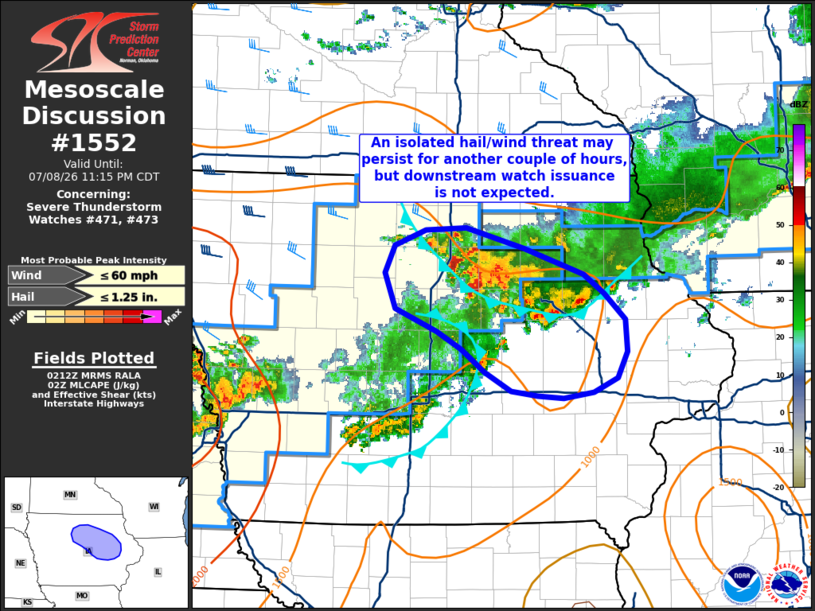
Mesoscale Discussion 1552 NWS Storm Prediction Center Norman OK 0915 PM CDT Wed Jul 08 2026 Areas affected...Central to northeast Iowa Concerning...Severe Thunderstorm Watch 471...473... Valid 090215Z - 090415Z The severe weather threat for Severe Thunderstorm Watch 471, 473 continues. SUMMARY...A threat for isolated hail will likely continue across portions of central to northeast Iowa for the next couple of hours. Downstream watch issuance is not expected. DISCUSSION...Over the past couple of hours, the cold pool associated with a weak convective band has continued to expand south/southwestward. New updrafts developing on the southern and western flanks of the cold pool have been quickly displaced into the cooler/more stable air due to the westerly mid-level flow regime. However, a few of these updrafts have shown periodic upticks in intensification up to near severe limits based on MRMS MESH and vertical ice data. Further southwest, new convective development is also noted along the outflow of an upstream decaying thunderstorm band. In general, this activity resides within an axis of relatively higher MUCAPE and continues to experience the influence of weak frontal ascent (plus more localized ascent along the outflows) and broad-scale lift from a low-amplitude upper wave traversing the Plains. Because of these factors, continued updraft development appears possible over the next 1-2 hours and may continue to pose a threat for sporadic large hail and perhaps isolated strong/severe wind gusts. Beyond the next couple of hours, continued nocturnal stabilization and diminishing buoyancy with southeastward extent will likely act to modulate updraft intensities. The net result should be a gradual decline in thunderstorm intensity and further reduction of the severe threat. While some severe threat may linger in the near-term on the periphery of WW 471 and 473, downstream watch issuance is not expected. ..Moore.. 07/09/2026 ...Please see www.spc.noaa.gov for graphic product... ATTN...WFO...DVN...ARX...DMX... LAT...LON 42899251 42679183 42519161 42309136 42039134 41819145 41689172 41639206 41659235 41709265 41859295 42049321 42199349 42399396 42689408 42919398 43049362 43069317 42899251 MOST PROBABLE PEAK WIND GUST...UP TO 60 MPH MOST PROBABLE PEAK HAIL SIZE...UP TO 1.25 IN |
|
|
Top/All Mesoscale Discussions/Forecast Products/Home |
|
Source link