| Mesoscale Discussion 1550 | |
| < Previous MD | |

|
|
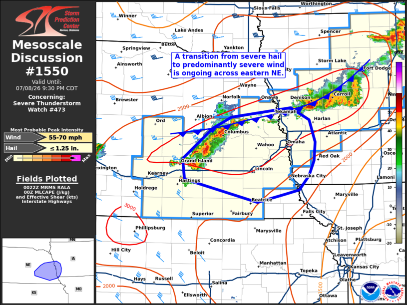
Mesoscale Discussion 1550 NWS Storm Prediction Center Norman OK 0725 PM CDT Wed Jul 08 2026 Areas affected...Eastern Nebraska into western Iowa Concerning...Severe Thunderstorm Watch 473... Valid 090025Z - 090230Z The severe weather threat for Severe Thunderstorm Watch 473 continues. SUMMARY...A transition from semi-discrete supercells to a linear storm mode has occurred and will promote an increase in severe winds downstream into eastern Nebraska and western Iowa. DISCUSSION...Over the past hour, KGID and KOAX imagery has shown a convective mode transition from predominately semi-discrete/clustered supercells to a linear band. Additionally, convective development continues to develop west/southwestward along a frontal boundary, and will likely merge with the developing band within the next hour or so. This activity will continue to propagate into the best regional thermodynamic environment, which features MLCAPE near 2500 J/kg and low-level lapse rates are near 7.5 C/km. This thermodynamic will favor further updraft development and cold pool development, especially considering adequate deep-layer bulk shear in place across the warm sector (the KOAX VWP continues to sample 0-6 km bulk shear values of around 30 knots). Consequently, some uptick in severe wind potential appears probable in the next couple of hours across eastern NE and possibly into western IA. The wind threat may be modulated to some degree by weak low-level winds sampled by the KOAX VWP, which may favor outflow-dominant convection. However, embedded swaths of severe winds behind the outflow will still be possible. ..Moore.. 07/09/2026 ...Please see www.spc.noaa.gov for graphic product... ATTN...WFO...EAX...OAX...GID... LAT...LON 40679823 41019828 41559760 41739717 41909582 41689541 41309528 40989531 40729542 40499564 40419596 40279659 40679823 MOST PROBABLE PEAK WIND GUST...55-70 MPH MOST PROBABLE PEAK HAIL SIZE...UP TO 1.25 IN |
|
|
Top/All Mesoscale Discussions/Forecast Products/Home |
|
Source link