

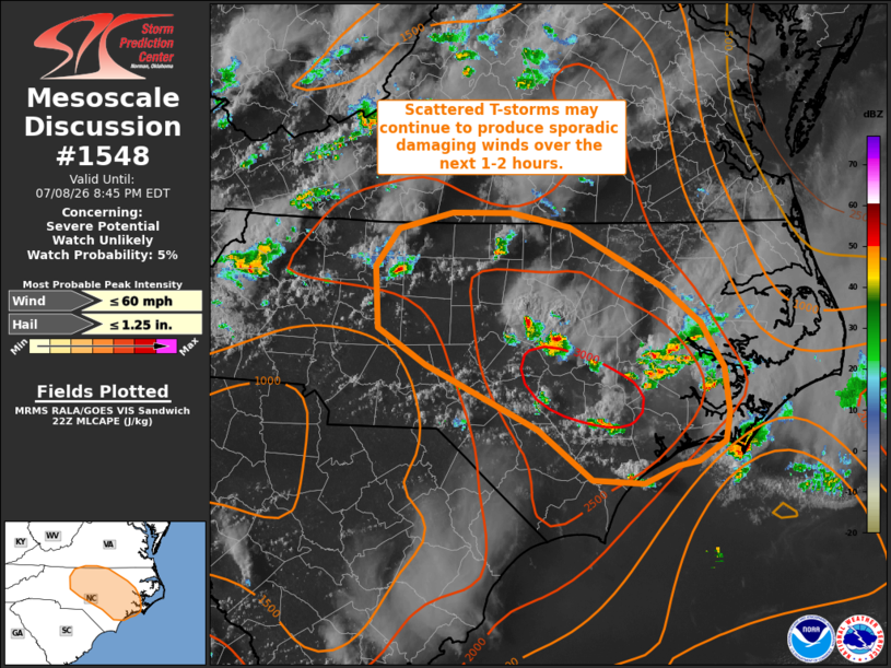
| Mesoscale Discussion 1548 | |
| < Previous MD | |

|
|
   Mesoscale Discussion 1548
   NWS Storm Prediction Center Norman OK
   0538 PM CDT Wed Jul 08 2026

   Areas affected...North Carolina

   Concerning...Severe potential...Watch unlikely

   Valid 082238Z - 090045Z

   Probability of Watch Issuance...5 percent

   SUMMARY...Thunderstorms continue to develop within a mesoscale
   confluence zone where buoyancy is regionally maximized. This
   activity may continue to produce damaging gusts over the next couple
   of hours before the onset of nocturnal cooling. Watch issuance is
   not expected.

   DISCUSSION...Convection ongoing across central to eastern NC has
   largely exhibited pulse behavior with downbursts notable in regional
   velocity imagery. However, a few wind damage reports have been noted
   over the past several hours. This activity has been focused along a
   mesoscale confluence zone noted in surface observations, which
   coincides with a regional buoyancy maximum with MLCAPE values
   estimated to be around 2000-2500 J/kg. Additionally, regional VWPs
   are sampling deep-layer wind shear values on the order of 25 knots,
   which is stronger than estimated by recent RAP mesoanalyses.
   Consequently, there is some potential for more loosely organized and
   persistent convection, which will maintain the potential for
   damaging winds and perhaps sporadic hail through late evening prior
   to the onset of nocturnal cooling/stabilization.

   ..Moore/Thompson.. 07/08/2026

   ...Please see www.spc.noaa.gov for graphic product...

   ATTN...WFO...AKQ...MHX...RAH...ILM...RNK...

   LAT...LON   34347754 34367808 34807865 35347980 35658029 36168032
               36498009 36627953 36627891 36517831 36007734 35697696
               35317672 34947666 34707670 34527698 34487720 34347754

   MOST PROBABLE PEAK WIND GUST...UP TO 60 MPH
   MOST PROBABLE PEAK HAIL SIZE...UP TO 1.25 IN
|
|
|
Top/All Mesoscale Discussions/Forecast Products/Home |
|
Source link