| Mesoscale Discussion 1538 | |
| < Previous MD Next MD > | |

|
|
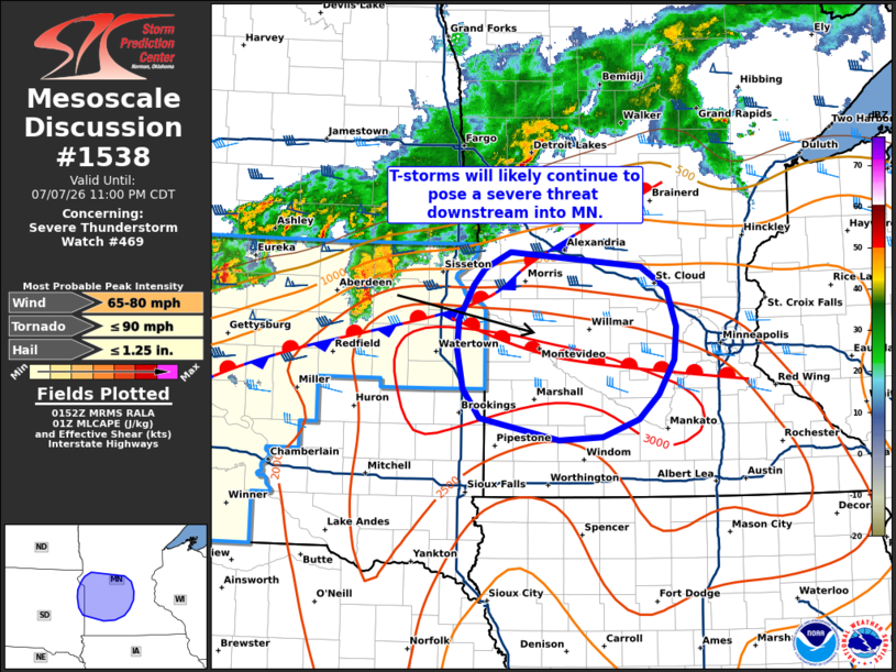
Mesoscale Discussion 1538 NWS Storm Prediction Center Norman OK 0854 PM CDT Tue Jul 07 2026 Areas affected...Northeast South Dakota into central Minnesota Concerning...Severe Thunderstorm Watch 469... Valid 080154Z - 080400Z The severe weather threat for Severe Thunderstorm Watch 469 continues. SUMMARY...A cluster of severe thunderstorms will likely spread east into central Minnesota over the next few hours. The downstream environment should support a continued severe wind threat. Downstream watch issuance probably be needed to address this concern. DISCUSSION...An elevated thunderstorm cluster migrating southeast across the Aberdeen, SD region has begun producing severe winds at the surface between 60-70 mph. This, coupled with a recent uptick in lightning counts and cooling cloud-top temperatures, strongly suggests that the cluster is utilizing the higher buoyancy in place across the region. Based on current storm tracks and latest mesoanalyses, this storm will continue to push into a regional buoyancy maximum, so further intensification appears probable over the next hour or so. Additionally, surface observations show a warm frontal zone draped from far northeast SD into central MN that is well aligned with the deep-layer bulk shear vector. This may act as a foci for storm propagation through the next few hours where a greater chance for severe wind could emerge. New storm development south of the ongoing cluster also appears possible over the next 1-2 hours as an outflow boundary from the cluster collides with a meandering boundary to the south. Any storms developing within this zone will likely also pose a threat for severe hail and eventually severe wind if/when upscale clustering occurs. Regardless, downstream watch issuance into central MN appears probable in the coming hours as storms continue to spread east. ..Moore.. 07/08/2026 ...Please see www.spc.noaa.gov for graphic product... ATTN...WFO...MPX...FGF...FSD...ABR... LAT...LON 44049544 44259651 44549674 44919683 45209681 45549660 45709646 45869611 45729433 45509398 45139385 44829389 44489409 44249436 44079486 44049544 MOST PROBABLE PEAK TORNADO INTENSITY...UP TO 90 MPH MOST PROBABLE PEAK WIND GUST...65-80 MPH MOST PROBABLE PEAK HAIL SIZE...UP TO 1.25 IN |
|
|
Top/All Mesoscale Discussions/Forecast Products/Home |
|
Source link