

| Mesoscale Discussion 1524 | |
| < Previous MD | |

|
|
   Mesoscale Discussion 1524
   NWS Storm Prediction Center Norman OK
   0311 PM CDT Mon Jul 06 2026

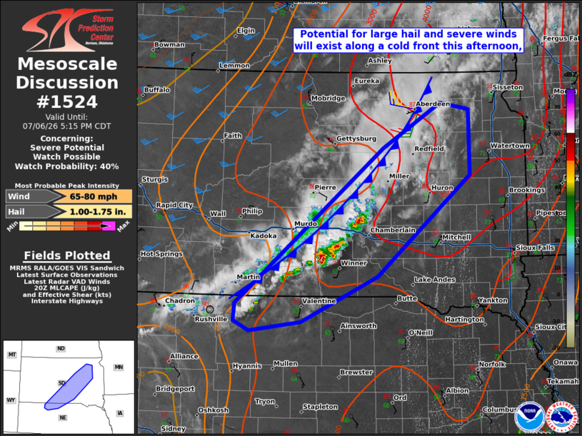
   Areas affected...North-central Nebraska into northeast South Dakota

   Concerning...Severe potential...Watch possible

   Valid 062011Z - 062215Z

   Probability of Watch Issuance...40 percent

   SUMMARY...Storms along a cold front will pose a threat of large hail
   and severe winds. Convective organization is not expected to be
   overly high, but trends will continue to be monitored.

   DISCUSSION...Convection has developed along a cold front in
   central/northeast South Dakota. Strong heating of an upper 60s to
   low 70s F dewpoint airmass has mostly eroded MLCIN faster than most
   earlier guidance had predicted. The observed 18Z ABR sounding showed
   an 8.4 C/km mid-level lapse rate, though some inhibition remains
   when modifying with current surface observations. The impacts of
   remaining MLCIN are apparent given that storms have not been able to
   intensify very quickly. With continued surface heating, however,
   strong to severe storms will become more likely along the boundary.
   These areas are much farther removed from the upper trough in Canada
   and mid-level heights are subtly rising as well. The less than ideal
   large-scale lift environment along with 20-25 kt of effective shear
   will likely limit overall storm organization and intensity. Large
   hail and severe wind gusts will still be possible with the strongest
   storms. Should enough clustering occur, a watch may need to be
   considered.

   ..Wendt/Hart.. 07/06/2026

   ...Please see www.spc.noaa.gov for graphic product...

   ATTN...WFO...FSD...ABR...LBF...UNR...

   LAT...LON   42890173 44949905 45549801 45459749 44599747 43259917
               42660054 42540148 42660175 42890173

   MOST PROBABLE PEAK WIND GUST...65-80 MPH
   MOST PROBABLE PEAK HAIL SIZE...1.00-1.75 IN
|
|
|
Top/All Mesoscale Discussions/Forecast Products/Home |
|
Source link