| Mesoscale Discussion 1487 | |
| < Previous MD | |

|
|
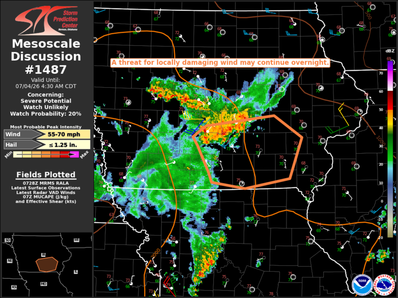
   Mesoscale Discussion 1487
   NWS Storm Prediction Center Norman OK
   0230 AM CDT Sat Jul 04 2026

   Areas affected...Parts of south-central/southeast IA

   Concerning...Severe potential...Watch unlikely

   Valid 040730Z - 040930Z

   Probability of Watch Issuance...20 percent

   SUMMARY...A threat for locally damaging wind may continue overnight.

   DISCUSSION...A notable outflow surge has occurred with persistent
   convection near Des Moines, where a 50 kt gust was recently
   observed. This cluster may continue to propagate southeastward in
   the short term, given the presence of rich low-level moisture and
   moderate buoyancy immediately downstream. This will result in a
   threat for at least locally damaging wind continuing for the next
   1-2 hours. The longevity of any severe threat may tend to be limited
   by modest deep-layer shear and the influence of decayed convection
   and attendant low/midlevel drying approaching the region from
   southwest IA.

   ..Dean/Mosier.. 07/04/2026

   ...Please see www.spc.noaa.gov for graphic product...

   ATTN...WFO...DVN...DMX...

   LAT...LON   41629367 41789220 41439159 40759186 40599283 40699355
               40879362 41309385 41439396 41629367

   MOST PROBABLE PEAK WIND GUST...55-70 MPH
   MOST PROBABLE PEAK HAIL SIZE...UP TO 1.25 IN
|
|
|
Top/All Mesoscale Discussions/Forecast Products/Home |
|
Source link