| Mesoscale Discussion 1474 | |
| < Previous MD | |

|
|
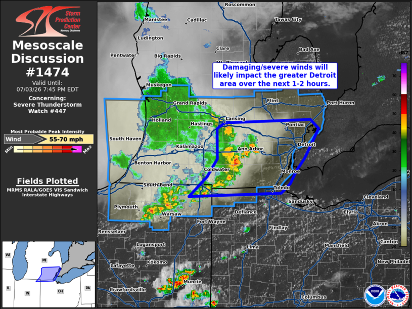
Mesoscale Discussion 1474 NWS Storm Prediction Center Norman OK 0442 PM CDT Fri Jul 03 2026 Areas affected...Southeast Lower Michigan Concerning...Severe Thunderstorm Watch 447... Valid 032142Z - 032345Z The severe weather threat for Severe Thunderstorm Watch 447 continues. SUMMARY...A broken line of thunderstorms continues to develop a cohesive cold pool, which will likely maintain the threat for damaging/severe winds over the next 1-2 hours as it approaches the greater Detroit area. DISCUSSION...Over the past hour, recent regional reflectivity and velocity data from Lower MI/northern IN depicts the gradual emergence of a more cohesive cold pool within an otherwise broken band of thunderstorms. Concurrently, GOES IR imagery has shown periodic bursts of intense updrafts and a gradual cooling trend in cloud-top temperatures, further suggesting that some organization/consolidation is occurring. Latest RAP mesoanalyses continue to show an MLCAPE gradient draped eastward across the greater Detroit area ahead of the convective band. Although deep-layer shear remains somewhat meager, propagation along this boundary appears likely over the next few hours. Based on latest storm track estimates, this band will begin to impact the greater Detroit area between the next 1-2 hours and will likely pose a threat for damaging/severe winds (most likely between 50-65 mph). ..Moore.. 07/03/2026 ...Please see www.spc.noaa.gov for graphic product... ATTN...WFO...CLE...DTX...IWX...GRR... LAT...LON 41578527 41888491 42168469 42628470 42718455 42768274 42638258 42348276 42168288 41978305 41788317 41628336 41578527 MOST PROBABLE PEAK WIND GUST...55-70 MPH |
|
|
Top/All Mesoscale Discussions/Forecast Products/Home |
|
Source link