| Mesoscale Discussion 1454 | |
| < Previous MD | |

|
|
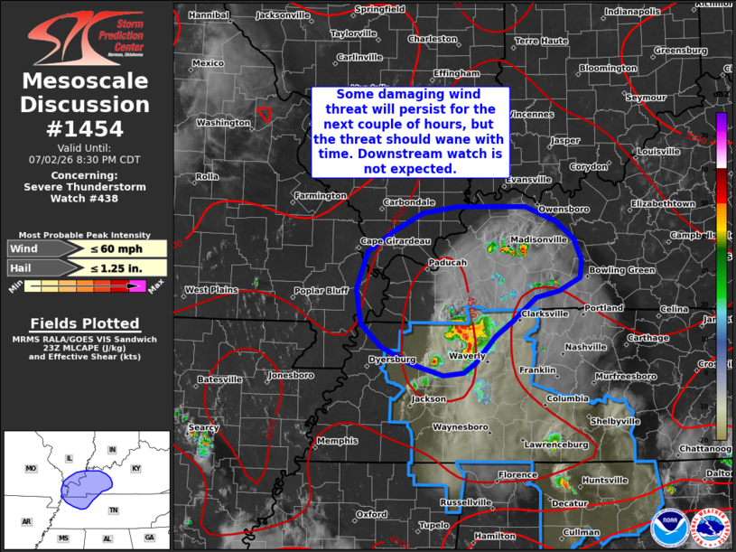
Mesoscale Discussion 1454 NWS Storm Prediction Center Norman OK 0632 PM CDT Thu Jul 02 2026 Areas affected...Northwest Tennessee into the lower Ohio Valley Concerning...Severe Thunderstorm Watch 438... Valid 022332Z - 030130Z The severe weather threat for Severe Thunderstorm Watch 438 continues. SUMMARY...Some damaging wind threat will likely persist across northwest Tennessee and into the lower Ohio River Valley through mid-evening, but the overall coverage and intensity of the wind threat should wane through the coming hours. Downstream watch issuance is not expected. DISCUSSION...Latest radar imagery from KPAH and KHPX shows an outflow boundary preceding deeper convection emanating out of middle TN that has a history of sporadic wind damage. Although recent wind reports have mostly been in the 25-30 mph range, velocity imagery continues to show pockets of stronger winds within the lowest 1-3 km that hint that isolated swaths of damaging winds remain possible in the near term with the primary cluster. Additionally, new convective development is noted on the northern fringe of the leading outflow boundary with additional new development possible given a weakly capped environment with around 4000 J/kg MLCAPE immediately downstream. With low-level lapse rates between 7 to 8 C/km, some downburst wind threat will likely persist for the next couple of hours. However, the approaching onset of nocturnal cooling will begin to diminish low-level lapse rates and gradually increase inhibition. This should begin to steadily modulate overall convective intensities and diminish the potential for damaging winds, especially after 02 UTC. Consequently, downstream watch issuance is currently not expected. ..Moore.. 07/02/2026 ...Please see www.spc.noaa.gov for graphic product... ATTN...WFO...LMK...OHX...PAH...MEG... LAT...LON 36838682 36768712 36518743 36348768 36068795 35958809 35928837 36048879 36248920 36488947 36868953 37268938 37478906 37688864 37758820 37748726 37588685 37398662 37168651 36978653 36838682 MOST PROBABLE PEAK WIND GUST...UP TO 60 MPH MOST PROBABLE PEAK HAIL SIZE...UP TO 1.25 IN |
|
|
Top/All Mesoscale Discussions/Forecast Products/Home |
|
Source link