| Mesoscale Discussion 1450 | |
| < Previous MD | |

|
|
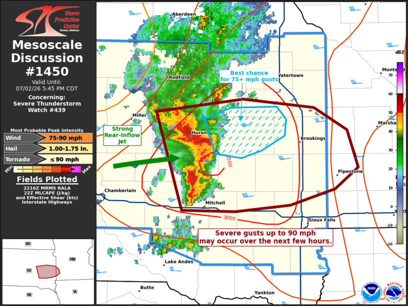
Mesoscale Discussion 1450 NWS Storm Prediction Center Norman OK 0519 PM CDT Thu Jul 02 2026 Areas affected...portions of eastern South Dakota into extreme southwestern Minnesota Concerning...Severe Thunderstorm Watch 439... Valid 022219Z - 022245Z The severe weather threat for Severe Thunderstorm Watch 439 continues. SUMMARY...A severe wind swath is underway with a compact MCS. Severe gusts up to 90 mph may occur over the next couple of hours. DISCUSSION...Initial supercells have grown upscale into a compact but intense cold-pool-driven MCS across eastern SD, with a recent history of gusts up to 90 mph reported. KFSD inbound velocity data shows a pronounced rear-inflow jet associated with this MCS, which is contributing to the MCS wind swath intensity. The MCS continues to traverse a diffuse outflow boundary, amid 3500 J/kg MLCAPE and 35 kts of effective bulk shear oriented normal to the MCS line (per 22Z mesoanalysis). The current thinking is that this MCS will maintain its current intensity for the next hour or so, with severe gusts likely. A couple of these gusts could reach 90 mph. ..Squitieri.. 07/02/2026 ...Please see www.spc.noaa.gov for graphic product... ATTN...WFO...FSD...ABR... LAT...LON 44589866 44719752 44639660 44419617 44079603 43879634 43719692 43659762 43679831 44589866 MOST PROBABLE PEAK TORNADO INTENSITY...UP TO 90 MPH MOST PROBABLE PEAK WIND GUST...75-90 MPH MOST PROBABLE PEAK HAIL SIZE...1.00-1.75 IN |
|
|
Top/All Mesoscale Discussions/Forecast Products/Home |
|
Source link